Wy/syl/ꠙꠣꠞ꠆ꠕ
Template:Wy/syl/PAGEBANNER:Perth CBD from Mill Point banner.jpg Template:Wy/syl/Otheruses Template:Wy/syl/PrintDistricts
Perth is the capital and largest city of Western Australia. It is separated from Adelaide (the nearest city with over 100,000 inhabitants) by a distance of 2,120 km, including the vast spaces of the Nullarbor Plain, making it one of the world's most isolated cities.
Perth spreads out along on a flat coastal plain, dissected by the Swan River, and spreads over the Darling Scarp to the east. The Indian Ocean coastline to the west is its only distinct physical boundary making it the most isolated continental city anywhere in the world.
Perth has a population of 2.2 million (2021), making it the fourth largest city in Australia.
Districts[edit | edit source]
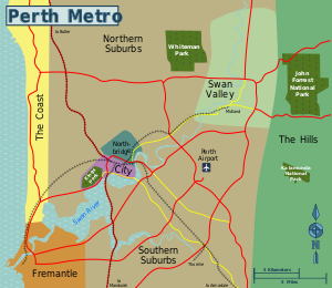
The official "City of Perth" is a small area on the north side of the Swan River, consisting of just the city centre. However, the Perth metropolitan area is much larger, spreading in all directions other than the ocean.

| City of Perth Where commerce and culture intermingle. |
| Northbridge Restaurants, bars, clubs, cafes and art. |
| Fremantle A historic port, now a food and entertainment destination. |
| The Coast The place for a swim and other activities. |
| Swan Valley A wide range of attractions in the Valley. |
| The Suburbs The low-density residential parts of Perth. |
Outside the city[edit | edit source]

| The Hills Wine, trees, hills, parks, and dams. |
| Outer Perth More distant towns and parks in the greater Perth region, generally 1-2 hours outside the CBD. |
| Rottnest Island Where locals like to relax and home to the irresistible quokkas. |
