Wp/knc/Antarctica
Appearance
Antarctica
| Part of | landmass, Antarctic, Earth |
|---|---|
| Named after | anti-, Arctic |
| Located in the administrative territorial entity | Antarctic Treaty area |
| Located in/on physical feature | Southern Hemisphere |
| Coordinate location | 90°0′0″S 0°0′0″E |
| Coordinates of easternmost point | no value |
| Coordinates of northernmost point | 63°12′48″S 57°18′8″W |
| Coordinates of southernmost point | 90°0′0″S 0°0′0″E |
| Coordinates of westernmost point | no value |
| Highest point | Vinson Massif |
| Lowest point | Bentley Subglacial Trench |
| Contains the administrative territorial entity | |
| Discoverer or inventor | Mikhail Lazarev, Fabian Gottlieb von Bellingshausen, First Russian Antarctic expedition |
| Top-level Internet domain | .aq |
| Main regulatory text | Antarctic Treaty System |
| Geography of topic | geography of Antarctica |
| History of topic | history of Antarctica |
| Country calling code | +672 |
| Unicode character | 🇦🇶 |
| Category for maps | Category:Maps of Antarctica |

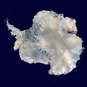
[1]Antarctica (/ænˈtɑːrktɪkə/ i) [note 1] shima cidi dunyabe cidiyanzayǝ kuru na kərmuye dən nabtəramzə gana. Suro cidi Antarctic Circle yǝ dǝn tǝrayin kuru Kǝrye Southern ye dǝn kǝlzǝyin (kǝrwe Antarctic yǝ dǝn tǝrayin), shi dǝn South Pole geographic ye dǝn mbeji. Antarctica dǝ shima kǝn indimi wo so dǝn kura wo, Europe dǝn 40% kura wo, kuru suronzǝ 14,200,000 km2 (5,500,000 sq mi). Nasha Antarctic bǝ ngəwuso sha Antarctic ice sheet bǝ dəa suwudə, nəmkuranzə kərye 1.9 km (1.2 mi).
Lamintǝ
[edit | edit source]

