Wp/iba/Nagoya
Appearance
Nagoya
名古屋市 | |
|---|---|
| Nickname: Chūkyō (中京) | |
<mapframe>: The JSON content is not valid GeoJSON+simplestyle. The list below shows all attempts to interpret it according to the JSON Schema. Not all are errors.
Interactive map outlining Nagoya | |
 Location of Nagoya in Aichi Prefecture | |
| Lua error in Module:Wp/iba/Location_map at line 524: Unable to find the specified location map definition: "Module:Wp/iba/Location map/data/Japan Kanto Chubu Kansai" does not exist. | |
| Coordinates: 35°11′N 136°54′E / 35.183°N 136.900°E | |
| Country | Japan |
| Region | Chūbu (Tōkai) |
| Prefecture | Aichi Prefecture |
| First official recorded | 199 AD |
| City Settled | November 1, 1889 |
| Government | |
| • Mayor | Takashi Kawamura (Template:Wp/iba/Polparty) |
| • Representatives | 5 |
| Pemesai | |
| • Designated city | 326.45 km2 (126.04 sq mi) |
| Penyampau mensia (June 1, 2021) | |
| • Designated city | 2,331,078 (3rd) |
| • Pemadat | 7,140.6/km2 (18,494/sq mi) |
| • Metro | 10,240,000 (3rd) |
| Time zone | UTC+09:00 (Japan Standard Time) |
| – Tree | Camphor laurel (Cinnamomum camphora) |
| – Flower | Lilium |
| Phone number | 052-972-2017 |
| Address | 3-1-1 Sannomaru, Naka-ku, Nagoya-shi, Aichi-ken 460-0001 |
| Website | www |
| [2] | |
| Wp/iba/Nagoya |
|---|
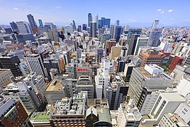
Nagoya (名古屋市, Nagoya-shi) iya nya mengeri ti pemadu besai ba kandang menua Chūbu di Jipun. Iya nyadi mengeri keempat pemadu mayuh mensia di Jipun, enggau penyampau tubuh 2.3 juta iku ba taun 2020, lalu nyadi mengeri besai ba kandang mengeri besai Chūkyō, ke nyadi kandang mengeri besai ketiga pemadu mayuh mensia di Jipun enggau penyampau tubuh 10.11 juta iku.[3] Bepalan ba tebing tasik Pasifik ba tengah Honshu, iya nyadi indu nengeri enggau mengeri ke pemadu mayuh mensia di Aichi Prefecture, enggau Palan Penyangkai Kapal Nagoya nyadi palan penyangkai kapal tasik pemadu besai Jipun.
Malin
- ↑ Demographia
- ↑ 平成23年6月1日現在の世帯数と人口(全市・区別) (id jaku Japanese). Diarkib ari asal on 22 September 2011. Diambi 19 June 2011.
- ↑ "Population of Japan". Japanese Statistics Bureau. 2010.


