Wp/dtp/Victoria, Australia
Script error: No such module "Wp/dtp/About". Template:Wp/dtp/Use Australian English
Page Template:Wp/dtp/Infobox political division/styles.css has no content.

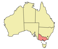
Victoria nopo nga wilayah bobos okoro do Australia i kosuang id benua dii (Tasmania au kohompit) om ribu-ribu bandaraya Melbourne. Victoria nopo nga id boogian tenggara benua Australia miampai ginumu mogigion 5,022,300 juta (Mahas 2005), nopo nga wilayah miampai mogigion tasapou koduo id Australia. Linaab nopo dii nga 237.629 km².
Sajara
Victoria nopo nga nokotongkiad mantad wilayah New South Wales om nosiliu koloni i nakagabas ontok toun 1851 kalapas kinaantakan perburuan emas bobos agayo id pomogunan soira norubaan o tambang-tambang emas id Ballarat om sumuduhut id Bendigo.
Ontok 1 Milatok 1901, notonduli o Victoria nosiliu wilayah id Persemakmuran Australia miagal wilayah-wilayah suai. Pogulu ibu negara Australia dinondo, Canberra, do nokoimagon, Melbourne nopo nga ibu negara Australia pointopot mantad toun 1901-1927.
Sukuon
- ↑ "Victoria, the garden state of Australia". Trove. Linoyog ontok 10 May 2023.
- ↑ Cite error: Invalid
<ref>tag; no text was provided for refs namedRecordOffice - ↑ "Area of Australia - States and Territories". 27 June 2014.
- ↑ "National, state and territory population – December 2022". Australian Bureau of Statistics. 15 June 2023. Linoyog ontok 19 June 2023.
- ↑ "5220.0 – Australian National Accounts: State Accounts, 2019–20". Australian Bureau of Statistics. 20 November 2020. Archived from the original on 17 June 2016. Linoyog ontok 20 January 2021.
- ↑ "Sub-national HDI – Area Database – Global Data Lab". hdi.globaldatalab.org. Archived from the original on 23 September 2018. Linoyog ontok 18 February 2023.


