
Wp/bgn/چێنیک کلات
| چێنیک کلات | |
|---|---|
| — Municipality — | |
 |
|
 چێنیک کلات |
|
| چارنیمه گ: 40°09′21″ شمالی 26°24′49″ شرقی / 40.15583° شمالی 26.41361° شرقی | |
| ملک | تورکیه |
| ولایت | چێنیک کلات |
| مزن | |
| • Mayor | Ülgür Gökhan (CHP) |
| • Kaymakam | |
| پراخیTemplate:Wp/bgn/Turkey district areas | |
| • District | Template:Wp/bgn/Turkey district areas km۲ (Formatting error: invalid input when rounding sq mi) |
| نپوس (Template:Wp/bgn/Turkey district populations)Template:Wp/bgn/Turkey district populations | |
| - شار | Template:Wp/bgn/Turkey district populations |
| • District | Template:Wp/bgn/Turkey district populations |
| ویب سایٹ | www |
چێنیک کلات (pronounced Template:Wp/bgn/IPA-tr) یکی شه تورکیه یی گوند شاران,بئ چێنیک کلات ولایت تا اینت, ای دمه گ(آسیا) و اوروپای مانجینا اینت . ای گوند شاری نپوس 186,116 نپر ات (۲۰۱۴ سالی تا).[1] The current mayor is Ülgür Gökhan (CHP).
نام
[edit | edit source]Çanakkale was an Ottoman fortress called Kale-i Sultaniye (Template:Wp/bgn/Lang-ota) or Sultaniye kalesi (Fortress of the Sultan). It later became known for its pottery, hence the later name Çanak kalesi 'pot fortress'
As of 1920, the British were calling Çanakkale, Chanak and Kale Sultanie in its reporting.
تاریخ
[edit | edit source]


چێنیک کلاتی مشهورین مردمان
[edit | edit source]- Nuri Bilge Ceylan (film director)
- Metin Erksan (film director)
- Ali Teoman Alpay (composer)
- Tevfik Rüştü Aras (Turkish foreign minister)
- İbrahim Bodur (entrepreneur)
- Mustafa Tutkun (humanitarian activist)
- Güney Dal (writer)
- Tahir Musa Ceylan (novelist/philosopher)
تعلیم
[edit | edit source]ترانسپورت
[edit | edit source]ارتباط
[edit | edit source]North of Canakkale at 40°10′17.66″ شمالی 26°24′34.34″ شرقی / 40.1715722° شمالی 26.4095389° شرقی, there is a guyed mast used for the maritime LF-transmitter TBG, working on 53.4 kHz.
آپ و هوا
[edit | edit source]Çanakkale has a mediterranean climate with hot and dry summers and cool and rainy winters. The land is arid, and snow falls ordinarily every winter.
| آپ و هوایی مالومات په چێنیک کلات خاتیرا | |||||||||||||
|---|---|---|---|---|---|---|---|---|---|---|---|---|---|
| ماه | جنوری | فیبروری | مارچ | اپریل | مای | جون | جولای | اگوست | سیپٹمبر | اوکتوبر | نومبر | ڈسمبر | سال |
| سابقهٔ بیشترین °C (°F) | ۱۹.۹ (67.82) |
۲۱.۲ (70.16) |
۲۴.۲ (75.56) |
۲۶.۱ (78.98) |
۳۲.۱ (89.78) |
۳۶.۸ (98.24) |
۳۹.۰ (102.2) |
۳۸.۶ (101.48) |
۳۵.۴ (95.72) |
۳۱.۷ (89.06) |
۲۵.۲ (77.36) |
۲۲.۵ (72.5) |
۳۹ (102.2) |
| میانگین بیشترین °C (°F) | ۹.۶ (49.28) |
۹.۸ (49.64) |
۱۲.۳ (54.14) |
۱۶.۹ (62.42) |
۲۲.۴ (72.32) |
۲۷.۷ (81.86) |
۳۰.۶ (87.08) |
۳۰.۳ (86.54) |
۲۶.۰ (78.8) |
۲۰.۵ (68.9) |
۱۵.۴ (59.72) |
۱۱.۳ (52.34) |
۱۹.۴ (66.92) |
| میانگین روزانه °C (°F) | ۶.۲ (43.16) |
۶.۵ (43.7) |
۸.۳ (46.94) |
۱۲.۵ (54.5) |
۱۷.۵ (63.5) |
۲۲.۴ (72.32) |
۲۵.۰ (77) |
۲۴.۸ (76.64) |
۲۰.۸ (69.44) |
۱۶.۰ (60.8) |
۱۱.۹ (53.42) |
۸.۴ (47.12) |
۱۵.۰۳ (59.045) |
| میانگین کمترین °C (°F) | ۳.۳ (37.94) |
۳.۴ (38.12) |
۵.۰ (41) |
۸.۷ (47.66) |
۱۲.۹ (55.22) |
۱۷.۱ (62.78) |
۱۹.۸ (67.64) |
۱۹.۹ (67.82) |
۱۶.۱ (60.98) |
۱۲.۳ (54.14) |
۸.۲ (46.76) |
۵.۳ (41.54) |
۱۱ (51.8) |
| سابقهٔ کمترین °C (°F) | −۸.۶ (16.52) |
−۱۱.۲ (11.84) |
−۸.۴ (16.88) |
−۱.۳ (29.66) |
۳.۴ (38.12) |
۸.۴ (47.12) |
۱۱.۶ (52.88) |
۱۱.۶ (52.88) |
۸.۲ (46.76) |
۰.۴ (32.72) |
−۲.۸ (26.96) |
−۷.۲ (19.04) |
−۱۱.۲ (11.84) |
| بارندگی میلیمتر (اینچ) | ۸۵.۳ (3.3583) |
۶۶.۲ (2.6063) |
۶۵.۸ (2.5906) |
۴۷.۳ (1.8622) |
۳۲.۱ (1.2638) |
۲۳.۱ (0.9094) |
۱۴.۶ (0.5748) |
۶.۹ (0.2717) |
۲۱.۹ (0.8622) |
۵۸.۰ (2.2835) |
۸۹.۱ (3.5079) |
۱۰۲.۴ (4.0315) |
۶۱۲.۷ (24.1222) |
| میانگین روزهای بارانی | ۱۰.۹ | ۱۰.۳ | ۹.۰ | ۸.۴ | ۵.۶ | ۴.۳ | ۳.۶ | ۲.۱ | ۳.۶ | ۶.۶ | ۹.۱ | ۱۲.۱ | ۸۵.۶ |
| میانگین روزانه ساعتهای تابش آفتاب | ۱۰۵.۴ | ۱۲۳.۲ | ۱۷۰.۵ | ۲۱۹.۰ | ۲۹۴.۵ | ۳۳۳.۰ | ۳۶۵.۸ | ۳۵۰.۳ | ۲۶۷.۰ | ۱۹۵.۳ | ۱۳۲.۰ | ۹۳.۰ | ۲,۶۴۹ |
| Source: Devlet Meteoroloji İşleri Genel Müdürlüğü [2] | |||||||||||||
اکس
[edit | edit source]-
 Çanakkale in 1915
 -
 Dardanelles on the Kitab-ı Bahriye
 -
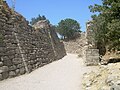 Portion of the legendary walls of Troy (VII)
 -
 A British war monument for the battle of gallipolli 1915
 -
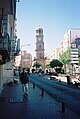 Çanakkale Clock Tower
 -
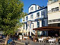
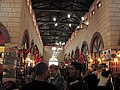 Aynalı Çarşı
 -
 View from Dardanelles strait
 -
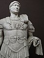 Hadrian Statue from Troia IX (BC 85 AD 450), found in the Odeon, Troy (Ilium), Canakkale Museum
 -

-
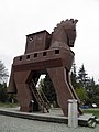 Troian horse
 -
 Çanakkale First Worldwar Cemetery
 -
 Çanakkale University Strategic Research Centre


.jpg)


,_found_in_the_Odeon,_Troy_(Ilium),_Canakkale_Museum_Turkey_(7446259522).jpg)

,_Turkey_(7446455084).jpg)


Twinships
[edit | edit source]- Template:Flagicon/core Pomezia, ایتالیا
- Template:Wp/bgn/Country data Wp/bgn/Germany Osnabrück, جرمنی
گیشتیر بوانیت
[edit | edit source]- Battle of Gallipoli
- Güzelyalı, a nearby town
- Chanak Crisis
گیپتجاه ئان
[edit | edit source]- Encyclopædia Britannica Eleventh Edition s.v. Dardanelles (town).
لینک په دنا
[edit | edit source]| به ویکی کومونز تا په Çanakkaleئ موضوعی خاتیرا فایل موجود انت. |
- Çanakkale
- Çanakkale Özel websitesi
- Pictures of the town and sub-galleries to major sights
- An overview of memorials, cemeteries and relics of the Gallipoli campaign, in Turkish known as the Canakkale wars.