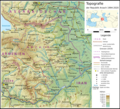
File:Topo map Arzach de.png
Appearance

Size of this preview: 662 × 599 pixels. Other resolutions: 265 × 240 pixels | 530 × 480 pixels | 848 × 768 pixels | 1,131 × 1,024 pixels | 2,262 × 2,048 pixels | 2,999 × 2,715 pixels.
Original file (2,999 × 2,715 pixels, file size: 8.69 MB, MIME type: image/png)
File history
Click on a date/time to view the file as it appeared at that time.
| Date/Time | Thumbnail | Dimensions | User | Comment | |
|---|---|---|---|---|---|
| current | 19:32, 13 June 2021 |  | 2,999 × 2,715 (8.69 MB) | Don-kun | kleine korrekturen und ergänzungen |
| 20:02, 2 November 2020 |  | 2,999 × 2,715 (8.68 MB) | Don-kun | kleine korrekturen | |
| 14:29, 31 October 2020 |  | 2,999 × 2,715 (8.67 MB) | Don-kun | more content | |
| 21:18, 25 October 2020 |  | 3,000 × 2,716 (8.29 MB) | Don-kun | {{Information |description ={{de|1=Topografische Karte der Republik Arzach (1994-2020), Arbeitsstand.}} |date =2020-10-25 |source ={{own}}; Topographischer Hintergrund: [http://www2.jpl.nasa.gov/srtm NASA Shuttle Radar Topography Mission] (public domain). SRTM3 v.2.<br /> Grenzen: Armenia adm location map.svg, Azerbaijan adm location map.svg |author =Don-kun }} [[Categor... |
File usage
There are no pages that use this file.
Global file usage
The following other wikis use this file:
- Usage on de.wikipedia.org
- Usage on lt.wikipedia.org

