
File:OxfordshireOxford.png
No higher resolution available.
OxfordshireOxford.png (200 × 267 pixels, file size: 17 KB, MIME type: image/png)
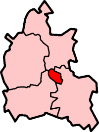
Oxford in Oxfordshire
Created by en:User:Morwen

|
Permission is granted to copy, distribute and/or modify this document under the terms of the GNU Free Documentation License, Version 1.2 or any later version published by the Free Software Foundation; with no Invariant Sections, no Front-Cover Texts, and no Back-Cover Texts. A copy of the license is included in the section entitled GNU Free Documentation License. |
| This file is licensed under the Creative Commons Attribution-Share Alike 3.0 Unported license. | ||
| ||
| This licensing tag was added to this file as part of the GFDL licensing update. |
File history
Click on a date/time to view the file as it appeared at that time.
| Date/Time | Thumbnail | Dimensions | User | Comment | |
|---|---|---|---|---|---|
| current | 09:55, 27 September 2005 | | 200 × 267 (17 KB) | Voyager | City of Oxford shown within Oxfordshire Map by en:User:Morwen Category:Maps of England |
File usage
There are no pages that use this file.
Global file usage
The following other wikis use this file:
- Usage on azb.wikipedia.org
- Usage on en.wikipedia.org
- Oxford
- Iffley
- Marston, Oxford
- Cowley, Oxfordshire
- Wolvercote
- Oxford East (UK Parliament constituency)
- Oxford West and Abingdon (UK Parliament constituency)
- Littlemore
- Port Meadow, Oxford
- Headington
- Blackbird Leys
- Risinghurst
- Grandpont
- Oxford (UK Parliament constituency)
- Jericho, Oxford
- Risinghurst and Sandhills
- Oxford City Council elections
- North Oxford
- Park Town, Oxford
- New Marston
- Cutteslowe
- Binsey, Oxfordshire
- Godstow
- Headington Rural District
- Osney
- Summertown, Oxford
- St Clement's, Oxford
- Headington Hill
- Rose Hill, Oxfordshire
- New Hinksey
- Hinksey
- Sunnymead
- Barton, Oxfordshire
- Donnington, Oxfordshire
- St. Ebbes
- Oxfordshire (UK Parliament constituency)
- Walton Manor
- Norham Manor
- Oxpens Road
- Template:Oxford
- User:Rst20xx/Contributions and Awards
- St John Street area
- Holywell, Oxford
- Northway, Oxford
- Waterways, Oxford
- Wood Farm, Oxfordshire
View more global usage of this file.