
File:Map of the Pacific region (currents).svg

Size of this PNG preview of this SVG file: 730 × 543 pixels. Other resolutions: 320 × 238 pixels | 640 × 476 pixels | 1,024 × 762 pixels | 1,280 × 952 pixels | 2,560 × 1,904 pixels.
Original file (SVG file, nominally 730 × 543 pixels, file size: 359 KB)
.svg)
Summary
| Description |
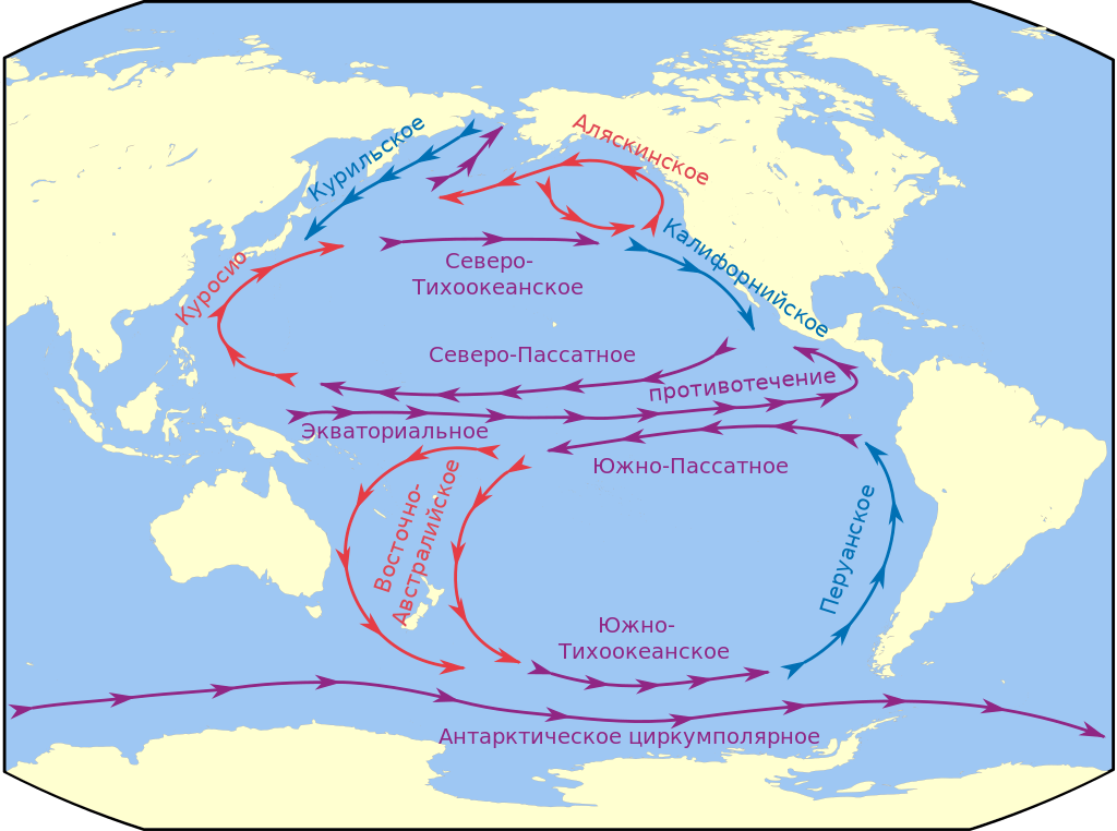
Русский: Течения Тихого океана |
| Date | |
| Source | на основе Map of the Pacific region.svg |
| Author |
|
.svg)
|
This SVG file contains embedded text that can be translated into your language, using any capable SVG editor, text editor or the SVG Translate tool. For more information see: About translating SVG files. |
.svg)
| This is a retouched picture, which means that it has been digitally altered from its original version. Modifications: +течения. The original can be viewed here: Map of the Pacific region.svg:
|
Licensing
This file is licensed under the Creative Commons Attribution-Share Alike 3.0 Unported license.
- You are free:
- to share – to copy, distribute and transmit the work
- to remix – to adapt the work
- Under the following conditions:
- attribution – You must give appropriate credit, provide a link to the license, and indicate if changes were made. You may do so in any reasonable manner, but not in any way that suggests the licensor endorses you or your use.
- share alike – If you remix, transform, or build upon the material, you must distribute your contributions under the same or compatible license as the original.
File history
Click on a date/time to view the file as it appeared at that time.
| Date/Time | Thumbnail | Dimensions | User | Comment | |
|---|---|---|---|---|---|
| current | 10:19, 16 March 2022 | | 730 × 543 (359 KB) | Ата | File uploaded using svgtranslate tool (https://svgtranslate.toolforge.org/). Added translation for uk. |
| 05:05, 16 March 2012 |  | 730 × 543 (355 KB) | Chtototakoe | ||
| 09:50, 11 March 2012 |  | 730 × 543 (345 KB) | Chtototakoe | == {{int:filedesc}} == {{Information |Description={{ru|1=Течения Тихого океана}} |Source=на основе Map of the Pacific region.svg |Author=*[[:File:Map of the Pacific region.svg|Map of th... |
File usage
There are no pages that use this file.
Global file usage
The following other wikis use this file:
- Usage on avk.wikipedia.org
- Usage on az.wikipedia.org
- Usage on ba.wikipedia.org
- Usage on ce.wikipedia.org
- Usage on fi.wikipedia.org
- Usage on fr.wikipedia.org
- Usage on ru.wikipedia.org
- Тихий океан
- Эоцен
- Антарктическое циркумполярное течение
- Южное Пассатное течение
- Североэкваториальное течение
- Восточно-Австралийское течение
- Калифорнийское течение
- Северо-Тихоокеанское течение
- Аляскинское течение
- Шаблон:Течения Тихого океана (карта изображений)
- Экваториальное противотечение
- Проект:Графическая мастерская/Заявки/Архив/2012/05
- Usage on ru.wikibooks.org
- Usage on uk.wikipedia.org
.svg)