
File:Guyane map-fr.svg

Size of this PNG preview of this SVG file: 497 × 600 pixels. Other resolutions: 199 × 240 pixels | 398 × 480 pixels | 637 × 768 pixels | 849 × 1,024 pixels | 1,698 × 2,048 pixels | 1,183 × 1,427 pixels.
Original file (SVG file, nominally 1,183 × 1,427 pixels, file size: 907 KB)
Summary
| Description |
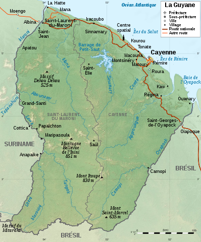
English: Map of French Guiana.
Français : Carte de la Guyane.
|
||
| Date | |||
| Source |
|
||
| Author | Sémhur | ||
| Other versions |
[] SVG
| ||
| Attribution (required by the license) | © Sémhur / Wikimedia Commons / | ||
| SVG | W3C-validity not checked.
|
||
| Graphic Lab |


| Camera location | | View this and other nearby images on: OpenStreetMap |
|---|
Licensing
I, the copyright holder of this work, hereby publish it under the following licenses:
| Copyleft: This work of art is free; you can redistribute it and/or modify it according to terms of the Free Art License. You will find a specimen of this license on the Copyleft Attitude site as well as on other sites. |
This file is licensed under the Creative Commons Attribution-Share Alike 4.0 International, 3.0 Unported, 2.5 Generic, 2.0 Generic and 1.0 Generic license.
- You are free:
- to share – to copy, distribute and transmit the work
- to remix – to adapt the work
- Under the following conditions:
- attribution – You must give appropriate credit, provide a link to the license, and indicate if changes were made. You may do so in any reasonable manner, but not in any way that suggests the licensor endorses you or your use.
- share alike – If you remix, transform, or build upon the material, you must distribute your contributions under the same or compatible license as the original.
You may select the license of your choice.
File history
Click on a date/time to view the file as it appeared at that time.
| Date/Time | Thumbnail | Dimensions | User | Comment | |
|---|---|---|---|---|---|
| current | 21:10, 29 July 2017 | | 1,183 × 1,427 (907 KB) | Triton | correction Dekou Dekou |
| 15:44, 28 January 2009 |  | 1,183 × 1,427 (907 KB) | Sémhur | Correcting two labels | |
| 15:10, 28 January 2009 |  | 1,183 × 1,427 (907 KB) | Sémhur | {{Information |Description={{en|1=Map of French Guiana.}} {{fr|1=Carte de la Guyane.}} |Source=travail personnel (own work). Sources : * File:Guyane department relief location map.jpg by {{u|Sting}} under licence |
File usage
There are no pages that use this file.
Global file usage
The following other wikis use this file:
- Usage on ar.wikipedia.org
- Usage on arz.wikipedia.org
- Usage on de.wikipedia.org
- Usage on es.wikipedia.org
- Usage on fr.wikipedia.org
- Liste de fleuves de France
- Guyane
- Discussion:Guyane
- Région ultrapériphérique
- Réseau routier de la Guyane
- Géographie de la Guyane
- Utilisateur:Elapied
- Massif du Mitaraka
- Discussion:Maripasoula
- Wikipédia:Atelier graphique/Cartes/Archives/janvier 2009
- Projet:Cartographie/Cartes standards/France
- Jean-Louis Loubère
- Patrimoine juif des départements, régions et territoires d’Outre-Mer
- Tampok
- Ouaqui
- Utilisateur:Peperwhite
- Utilisateur:Exp JC/Brouillon
- Usage on fr.wikinews.org
- Usage on fr.wikiversity.org
- Usage on gcr.wikipedia.org
- Usage on it.wikipedia.org
- Usage on mg.wikipedia.org
- Usage on nl.wikipedia.org
- Usage on pcd.wikipedia.org
- Usage on pl.wikipedia.org
- Usage on ro.wikipedia.org
- Usage on sco.wikipedia.org
- Usage on stq.wikipedia.org
- Usage on to.wikipedia.org
- Usage on www.wikidata.org