
File:Map Peloponnesian War 431 BC-es.svg

Size of this PNG preview of this SVG file: 749 × 600 pixels. Other resolutions: 300 × 240 pixels | 600 × 480 pixels | 960 × 768 pixels | 1,279 × 1,024 pixels | 2,559 × 2,048 pixels | 992 × 794 pixels.
Original file (SVG file, nominally 992 × 794 pixels, file size: 4.48 MB)
This W3C-unspecified vector image was created with Inkscape .
Summary
| Description |
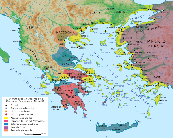
Español: Mapa del mundo egeo hacia el 431 a. C., al advenimiento de la Guerra del Peloponeso. |
||||||||
| Date | (French original); 2007-10-12 (Spanish translation) | ||||||||
| Source |
Création personnelle avec Adobe Illustrator (données basées sur E. Lévy, La Grèce au Ve siècle, Paris, 1995). Transcripción española según M. F. Galiano, La transcripción castellana de los nombres propios griegos, Madrid, 1969. |
||||||||
| Author | Marsyas (French original); Molorco (Spanish translation) | ||||||||
| Permission (Reusing this file) |
I, the copyright holder of this work, hereby publish it under the following licenses:
This file is licensed under the Creative Commons Attribution-Share Alike 2.5 Generic license.
You may select the license of your choice. |
||||||||
| Other versions |
Derivative works of this file: Mapa Grecia Antigua.svg
[]
|


|
This SVG file contains embedded text that can be translated into your language, using any capable SVG editor, text editor or the SVG Translate tool. For more information see: About translating SVG files. |
File history
Click on a date/time to view the file as it appeared at that time.
| Date/Time | Thumbnail | Dimensions | User | Comment | |
|---|---|---|---|---|---|
| current | 05:28, 10 February 2017 | | 992 × 794 (4.48 MB) | Rowanwindwhistler | Fake text added |
| 08:05, 25 February 2016 |  | 992 × 794 (3.63 MB) | Rowanwindwhistler | Wrong map... | |
| 07:57, 25 February 2016 |  | 993 × 794 (3.11 MB) | Rowanwindwhistler | Background map improved, from https://commons.wikimedia.org/wiki/File:MapaTopogr%C3%A1ficoDeAlbaniaGreciaYElEgeo.svg | |
| 10:47, 24 February 2016 |  | 993 × 794 (3.11 MB) | Rowanwindwhistler | Sea & coast from https://commons.wikimedia.org/wiki/File:Map_Macedonia_336_BC-es.svg | |
| 05:37, 8 July 2015 |  | 993 × 794 (3.4 MB) | Rowanwindwhistler | Sea colour changed as per https://en.wikipedia.org/wiki/Wikipedia:WikiProject_Maps/Conventions, better contrast with text labels | |
| 21:44, 12 October 2007 |  | 993 × 794 (3.4 MB) | Molorco | == Description == {{Information |Description= {{es|Mapa del mundo egeo hacia el 431 adC, al advenimiento de la Guerra del Peloponeso.}} {{fr|Carte du monde égéen en 431 av. J.-C., à la veille de la Guerre du Péloponnèse.}} |Source=Création personnel |
File usage
The following page uses this file:
Global file usage
The following other wikis use this file:
- Usage on ca.wikipedia.org
- Usage on de.wikipedia.org
- Usage on eo.wikipedia.org
- Usage on es.wikipedia.org
- Usage on et.wikipedia.org
- Usage on gl.wikipedia.org
- Usage on it.wikipedia.org
- Usage on ja.wikipedia.org
- Usage on lt.wikipedia.org
- Usage on sr.wikipedia.org