
File:Xinjiang nationalities by prefecture 2000.png

Size of this preview: 725 × 600 pixels. Other resolutions: 290 × 240 pixels | 581 × 480 pixels | 929 × 768 pixels | 1,238 × 1,024 pixels | 1,474 × 1,219 pixels.
Original file (1,474 × 1,219 pixels, file size: 129 KB, MIME type: image/png)

|
This ethnographic map image could be re-created using vector graphics as an SVG file. This has several advantages; see Commons:Media for cleanup for more information. If an SVG form of this image is available, please upload it and afterwards replace this template with
{{vector version available|new image name}}.
It is recommended to name the SVG file “Xinjiang nationalities by prefecture 2000.svg”—then the template Vector version available (or Vva) does not need the new image name parameter. |
Summary
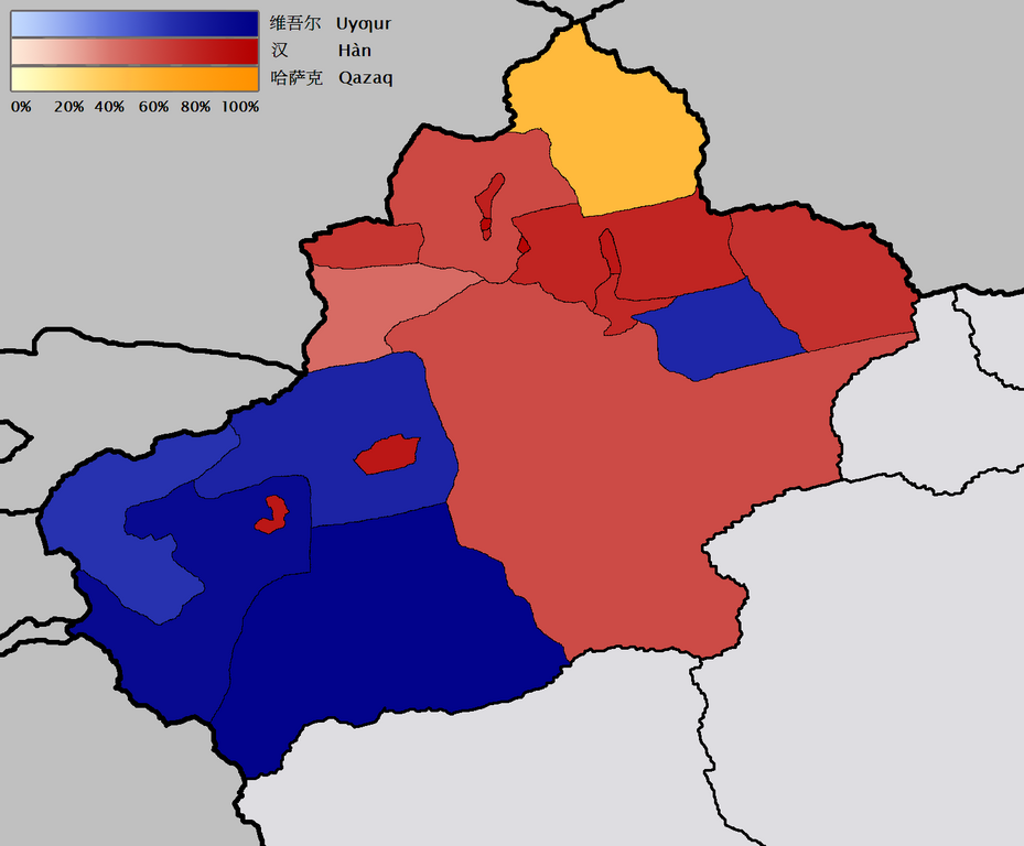
English: Map of the prefecture-level divisions of Xinjiang by ethnicity (nationality or 民族). 2000 census information is from w:en and w:de. The basis of the map is Image:Bayin Gholin.png, but I rotated the map so that the meridians are more nearly vertical, and also removed the background noise. I borrowed the colour scale from the Image:Canada election 2006 v2.png. QuartierLatin1968 21:20, 28 January 2006 (UTC)
Türkçe: Sincan'ın il düzeyi bölgelerindeki çoğunluğu oluşturan farklı etnik gruplar (minzu 民族). 2000 yılı nüfus verileri w:en ve w:de'den kaynaklanır. Haritanın temeli Image:Bayin Gholin.png'den alınmıştır, fakat meridyenleri daha dikey şekilde göstermek için harita döndürülmüştür ve gereksiz arka plan detayları çıkarılmıştır. Renk şeması Image:Canada election 2006 v2.png'den alınmıştır.
中文:新疆地域按民族(民族或民族)劃分的地圖。 2000年的人口普查信息來自w:en和w:de。 該地圖的基礎是Image:Bayin Gholin.png,但是我旋轉了地圖,使子午線更加接近垂直,並且還消除了背景噪音。 我從Image:Canada election 2006 v2.png中藉用了色階。 QuartierLatin196821:20,2006年1月28日(UTC)
Licensing
I, the copyright holder of this work, hereby publish it under the following licenses:

|
Permission is granted to copy, distribute and/or modify this document under the terms of the GNU Free Documentation License, Version 1.2 or any later version published by the Free Software Foundation; with no Invariant Sections, no Front-Cover Texts, and no Back-Cover Texts. A copy of the license is included in the section entitled GNU Free Documentation License. |
| This file is licensed under the Creative Commons Attribution-Share Alike 3.0 Unported license. | ||
| ||
| This licensing tag was added to this file as part of the GFDL licensing update. |
This file is licensed under the Creative Commons Attribution-Share Alike 2.5 Generic, 2.0 Generic and 1.0 Generic license.
- You are free:
- to share – to copy, distribute and transmit the work
- to remix – to adapt the work
- Under the following conditions:
- attribution – You must give appropriate credit, provide a link to the license, and indicate if changes were made. You may do so in any reasonable manner, but not in any way that suggests the licensor endorses you or your use.
- share alike – If you remix, transform, or build upon the material, you must distribute your contributions under the same or compatible license as the original.
You may select the license of your choice.
File history
Click on a date/time to view the file as it appeared at that time.
| Date/Time | Thumbnail | Dimensions | User | Comment | |
|---|---|---|---|---|---|
| current | 21:43, 28 January 2006 | | 1,474 × 1,219 (129 KB) | QuartierLatin1968 | adjusted Xizang/Qinghai boundary |
| 21:20, 28 January 2006 |  | 1,474 × 1,219 (129 KB) | QuartierLatin1968 | * {{en}}: Map of the prefecture-level divisions of Xinjiang by ethnicity (nationality or 民族). 2000 census information is from w:en and w:de. The basis of the map is Image:Bayin Golin.png, but I rotated the map so that the meridians |
File usage
The following 2 pages use this file:
Global file usage
The following other wikis use this file:
- Usage on af.wikipedia.org
- Usage on ast.wikipedia.org
- Usage on azb.wikipedia.org
- Usage on az.wikipedia.org
- Usage on ba.wikipedia.org
- Usage on bcl.wikipedia.org
- Usage on bg.wikipedia.org
- Usage on ca.wikipedia.org
- Usage on da.wikipedia.org
- Usage on de.wikipedia.org
- Usage on en.wikipedia.org
- Usage on eo.wikipedia.org
- Usage on es.wikipedia.org
- Usage on fr.wikipedia.org
- Usage on gl.wikipedia.org
- Usage on hr.wikipedia.org
- Usage on ja.wikipedia.org
- Usage on kk.wikipedia.org
- Usage on la.wikipedia.org
- Usage on lez.wikipedia.org
- Usage on lv.wikipedia.org
- Usage on mn.wikipedia.org
- Usage on ms.wikipedia.org
- Usage on nl.wikipedia.org
- Usage on nn.wikipedia.org
- Usage on no.wikipedia.org
- Usage on oc.wikipedia.org
- Usage on pt.wikipedia.org
- Usage on ru.wikipedia.org
- Usage on sr.wikipedia.org
View more global usage of this file.