
File:Twelve-jyotirlingas-map.jpg

Original file (1,710 × 1,733 pixels, file size: 132 KB, MIME type: image/jpeg)
घटिया वेबसाइट है ये इसपर दिया गया कोई भी जानकारी हमारे किसी काम का नही।। ये ढोंगी हमारे देश के संप्रभुता के साथ खेलवार कर रहा है जम्मू कश्मीर और सिक्किम अरुणाचल प्रदेश सब का मैप गलत दिखा कर सब को भ्रमित कर रहा है।
Yes this map of India is wrong. Jammu & Kashmir is integral part of India. POK is Indian land, which is in unauthorised occupation by Pakistan. Be aware new youtubers while using this map it will attract report and strike to your channel if someone uses it
आप के द्वारा प्रस्तूत भारतीय नक्षा गलत है यह नक्षे मे जम्मू काश्मीर के कुछ हिस्से जोडे नही है जबकी जम्मू और काश्मीर भारत के अभिन्न अंग है कृपया अपनी गलती सुधार के नया नक्षा प्रस्तुत करे अन्यथा आप्पे कानुनी प्रक्रिया अंतर्गत कारवाई हो शकती है ..
Peacefully saying... Madharchod map change kr de ben ke lovde🙂👍

]]
Summary
| Description |
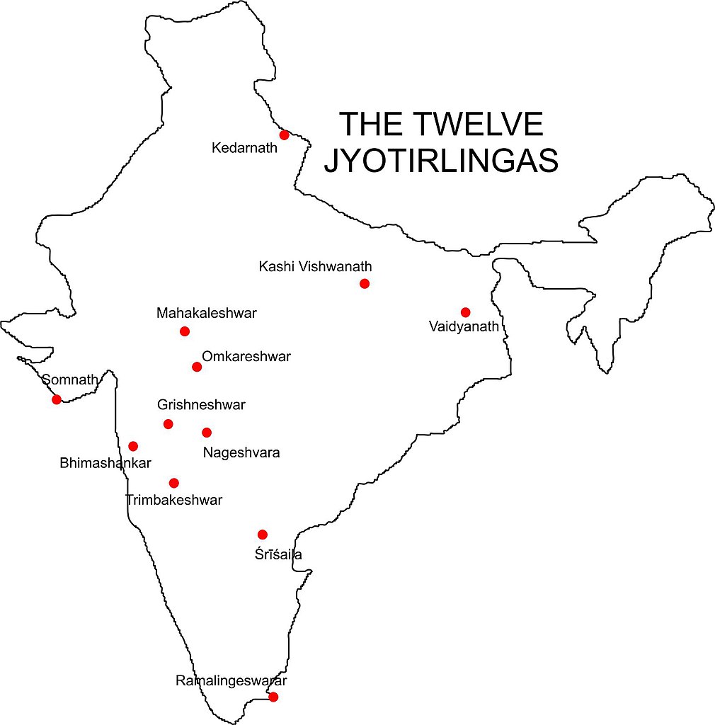
English: Map showing the location of each of the 12 Jyotirlinga temples in India: Kedarnath, Kashi Vishwanath, Vaidyanath, Mahakaleshwar, Omkareshwar, Somnath, Grishneshwar J (also Ghushmeshwar), Nageshvara, Bhimashankar, Trimbakeshwar, Mallikārjuna or Śrīśaila, and Ramalingeswarar. |
| Date | |
| Source | Own work |
| Author | WikiJedits |
Licensing
| I, the copyright holder of this work, release this work into the public domain. This applies worldwide. In some countries this may not be legally possible; if so: I grant anyone the right to use this work for any purpose, without any conditions, unless such conditions are required by law. |
MC BC PAHALE INDIA KA MAP SAHI KAR NAHI TO WEB SITE GRAND ME DAAL LE
File history
Click on a date/time to view the file as it appeared at that time.
| Date/Time | Thumbnail | Dimensions | User | Comment | |
|---|---|---|---|---|---|
| current | 02:11, 9 August 2009 | | 1,710 × 1,733 (132 KB) | WikiJedits | {{Information |Description={{en|1=Map showing the location of each of the 12 Jyotirlinga temples in India: Kedarnath, Kashi Vishwanath, Vaidyanath, Mahakaleshwar, Omkareshwar, Somnath, Grishneshwar J (also Ghushmeshwar), Nageshvara, Bhimashankar, Trimbake |
File usage
The following page uses this file:
Global file usage
The following other wikis use this file:
- Usage on kn.wikipedia.org
- Usage on pl.wikipedia.org
- Usage on sq.wikipedia.org