
File:The States of Austria Numbered.svg

Size of this PNG preview of this SVG file: 512 × 280 pixels. Other resolutions: 320 × 175 pixels | 640 × 350 pixels | 1,024 × 560 pixels | 1,280 × 700 pixels | 2,560 × 1,400 pixels.
Original file (SVG file, nominally 512 × 280 pixels, file size: 68 KB)
Summary
| Description |
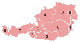
Deutsch: Karte der Bundesländer Österreichs.
English: Map of the States of Austria.
Français : Carte des Länder autrichiens.
Svenska: Karta över Österrikes förbundsländer. |
|||
| Date | ||||
| Source |
This file was derived from: Karte A Wien.svg |
|||
| Author |
Original: Vector: . |
|||
| Permission (Reusing this file) |
|
|||
| SVG development | This vector image was created with an unknown SVG tool.
|


File history
Click on a date/time to view the file as it appeared at that time.
| Date/Time | Thumbnail | Dimensions | User | Comment | |
|---|---|---|---|---|---|
| current | 00:41, 25 December 2012 | | 512 × 280 (68 KB) | GeMet | {{Information |Description = {{de|Karte der Bundesländer Österreichs.}} {{en|Map of the States of Austria.}} {{fr|Carte des Länder autrichiens.}} {{sv|Karta öve... |
File usage
The following page uses this file:
Global file usage
The following other wikis use this file:
- Usage on ami.wikipedia.org
- Usage on an.wikipedia.org
- Usage on ar.wikipedia.org
- Usage on azb.wikipedia.org
- Usage on az.wikipedia.org
- Usage on ba.wikipedia.org
- Usage on be-tarask.wikipedia.org
- Usage on be.wikipedia.org
- Usage on bs.wikipedia.org
- Usage on ca.wikipedia.org
- Usage on cs.wikipedia.org
- Usage on de.wikipedia.org
- Usage on de.wikinews.org
- Usage on el.wikipedia.org
- Usage on eml.wikipedia.org
- Usage on en.wikipedia.org
- Usage on eo.wikipedia.org
- Usage on es.wikipedia.org
- Usage on et.wikipedia.org
- Usage on eu.wikipedia.org
- Usage on fa.wikipedia.org
- Usage on frr.wikipedia.org
- Usage on fr.wikipedia.org
- Usage on gag.wikipedia.org
- Usage on gd.wikipedia.org
- Usage on gl.wikipedia.org
- Usage on he.wikipedia.org
View more global usage of this file.