
File:SF and Bay Bridge.JPG

Size of this preview: 800 × 600 pixels. Other resolutions: 320 × 240 pixels | 640 × 480 pixels | 1,024 × 768 pixels | 1,136 × 852 pixels.
Original file (1,136 × 852 pixels, file size: 750 KB, MIME type: image/jpeg)
|
This is an image of a place or building that is listed on the National Register of Historic Places in the United States of America. Its reference number is 525. |
Summary
| Description |
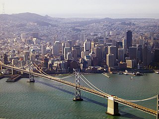
English: The San Francisco skyline and the western span of the San Francisco-Oakland Bay Bridge taken from the air.
中文:舊金山-奧克蘭海灣大橋.
العربية: جسر سان فرانسيسكو-أوكلاند. |
||||||||
| Date | |||||||||
| Source | en:User:Sam | ||||||||
| Author | en:User:Sam | ||||||||
| Permission (Reusing this file) |
|

| Object location | | View this and other nearby images on: OpenStreetMap |
|---|
File history
Click on a date/time to view the file as it appeared at that time.
| Date/Time | Thumbnail | Dimensions | User | Comment | |
|---|---|---|---|---|---|
| current | 07:41, 28 December 2011 | | 1,136 × 852 (750 KB) | Sam | adjusted color and exposure |
| 09:48, 9 March 2007 |  | 1,136 × 852 (327 KB) | Wolfgang K |
File usage
The following 2 pages use this file:
Global file usage
The following other wikis use this file:
- Usage on ar.wikipedia.org
- Usage on de.wikipedia.org
- Usage on en.wikipedia.org
- Usage on fi.wikipedia.org
- Usage on it.wikipedia.org
- Usage on ko.wikipedia.org
- Usage on nl.wikipedia.org
- Usage on ru.wikipedia.org