
File:Rhode Island population map.png
No higher resolution available.
Rhode_Island_population_map.png (600 × 600 pixels, file size: 124 KB, MIME type: image/png)
Summary
| Description |
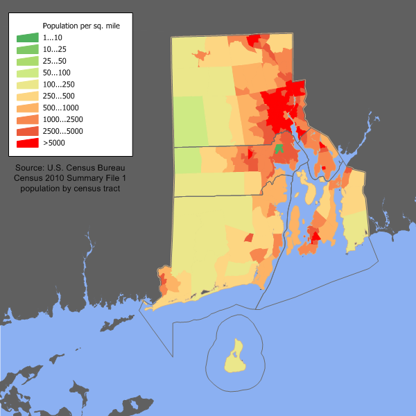
English: Rhode Island population density map based on Census 2010. See the process description for the data lineage. |
| Date | 17 February 2006 (original upload date) |
| Source | Transferred from en.wikipedia to Commons by Pauk using CommonsHelper. |
| Author | JimIrwin at English Wikipedia |
Licensing
JimIrwin at the English Wikipedia, the copyright holder of this work, hereby publishes it under the following license:

|
Permission is granted to copy, distribute and/or modify this document under the terms of the GNU Free Documentation License, Version 1.2 or any later version published by the Free Software Foundation; with no Invariant Sections, no Front-Cover Texts, and no Back-Cover Texts. A copy of the license is included in the section entitled GNU Free Documentation License. |
| This file is licensed under the Creative Commons Attribution-Share Alike 3.0 Unported license. | ||
| Attribution: JimIrwin at the English Wikipedia | ||
| ||
| This licensing tag was added to this file as part of the GFDL licensing update. |
Original upload log
The original description page was here. All following user names refer to en.wikipedia.
- 2006-02-17 13:17 JimIrwin 620×450× (23652 bytes) Rhode Island population density map based on Census 2000
File history
Click on a date/time to view the file as it appeared at that time.
| Date/Time | Thumbnail | Dimensions | User | Comment | |
|---|---|---|---|---|---|
| current | 14:32, 11 December 2011 | | 600 × 600 (124 KB) | JimIrwin | 2010 census update |
| 05:30, 20 June 2011 |  | 620 × 450 (23 KB) | File Upload Bot (Magnus Manske) | {{BotMoveToCommons|en.wikipedia|year={{subst:CURRENTYEAR}}|month={{subst:CURRENTMONTHNAME}}|day={{subst:CURRENTDAY}}}} {{Information |Description={{en|en:Category:United States state population maps en:Category:Rhode Island maps Rhode Island |
File usage
The following page uses this file:
Global file usage
The following other wikis use this file:
- Usage on cy.wikipedia.org
- Usage on de.wikipedia.org
- Usage on en.wikipedia.org
- Usage on es.wikipedia.org
- Usage on fr.wikipedia.org
- Usage on fy.wikipedia.org
- Usage on he.wikipedia.org
- Usage on ja.wikipedia.org
- Usage on kn.wikipedia.org
- Usage on pt.wikipedia.org
- Usage on ro.wikipedia.org
- Categorie:Statul Rhode Island, SUA
- Rhode Island
- Format:Rhode Island stat SUA
- Listă de comitate din statul Rhode Island
- Categorie:Liste Rhode Island
- Noua Anglie
- Categorie:Guvernatori ai statului Rhode Island
- Listă de oameni din statul Rhode Island
- Categorie:Guvernul statului Rhode Island
- Listă de orașe din statul Rhode Island
- Categorie:Zone metropolitane din Rhode Island
- Categorie:Zone micropolitane din Rhode Island
- Categorie:Localități din Rhode Island
- Categorie:Cultură în statul Rhode Island
- Categorie:Regiuni ale statului Rhode Island
- Categorie:Instituții de învățământ superior din Rhode Island
- Categorie:Membri ai legislaturii statului Rhode Island
- Categorie:Absolvenți din Rhode Island după instituția de învățământ superior
- Categorie:Oameni din statul Rhode Island după institutul de învățământ superior
- Categorie:Târguri din statul Rhode Island
- Categorie:Municipalități din statul Rhode Island
- Categorie:Localități costale din Rhode Island
- Categorie:Insule ale statului Rhode Island
- Categorie:Sate din statul Rhode Island
- Categorie:Locuri desemnate pentru recensământ din statul Rhode Island
- Categorie:Subdiviziunile statului Rhode Island
- Categorie:Istoria naturală a statului Rhode Island
- Categorie:Dezastre naturale din statul Rhode Island
- Categorie:Dezastre din statul Rhode Island
- Categorie:Politica statului Rhode Island
- Categorie:Legislatura statului Rhode Island
- Categorie:2012 în statul Rhode Island
- Categorie:Ani în Rhode Island
- Categorie:Uragane în statul Rhode Island
View more global usage of this file.