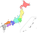
File:Regions and Prefectures of Japan (ja).svg

Size of this PNG preview of this SVG file: 468 × 599 pixels. Other resolutions: 187 × 240 pixels | 375 × 480 pixels | 600 × 768 pixels | 800 × 1,024 pixels | 1,600 × 2,048 pixels | 2,480 × 3,175 pixels.
Original file (SVG file, nominally 2,480 × 3,175 pixels, file size: 117 KB)
File history
Click on a date/time to view the file as it appeared at that time.
| Date/Time | Thumbnail | Dimensions | User | Comment | |
|---|---|---|---|---|---|
| current | 19:00, 18 September 2020 |  | 2,480 × 3,175 (117 KB) | Drhyme | File uploaded using svgtranslate tool (https://svgtranslate.toolforge.org/). Added translation for ko. |
| 16:02, 18 September 2020 |  | 2,480 × 3,175 (109 KB) | Drhyme | File uploaded using svgtranslate tool (https://svgtranslate.toolforge.org/). Added translation for ko. | |
| 05:15, 3 March 2009 |  | 2,480 × 3,175 (191 KB) | Pqks758 | {{Information |Description={{en|1=Map of the regions and prefectures of Japan in ISO 3166-2:JP order.}} {{ja|1=日本の地域と都道府県の地図。ISO自治体番号順。}} |Source=Own work by uploader |Author=[[User:Pqk |
File usage
There are no pages that use this file.
Global file usage
The following other wikis use this file:
- Usage on en.wikipedia.org
- Usage on ja.wikipedia.org
- Usage on ja.wikibooks.org
- Usage on ja.wikivoyage.org


