
File:Nagaland in India.png
Nagaland_in_India.png (350 × 426 pixels, file size: 76 KB, MIME type: image/png)
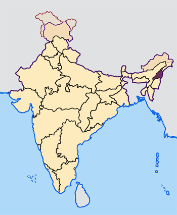
Map made by me, Nichalp
Note: The Indian state of w:Jammu and Kashmir is claimed by w:India, w:Pakistan and the w:People's Republic of China. This map depicts the boundaries of the state as it was in 1947. Areas administered by India is coloured as per the rest of the states, and the area administered by Pakistan and China are coloured in a neutral colour. See the map of Jammu and Kashmir.
The Indian state of w:Arunachal Pradesh is claimed by China as a part of w:South Tibet. The claimed region is depicted in a pale shade of pink. See the map of Arunachal Pradesh.
The Indian territorial waters extend to a distance of twelve nautical miles.

|
Permission is granted to copy, distribute and/or modify this document under the terms of the GNU Free Documentation License, Version 1.2 or any later version published by the Free Software Foundation; with no Invariant Sections, no Front-Cover Texts, and no Back-Cover Texts. A copy of the license is included in the section entitled GNU Free Documentation License. |
| This file is licensed under the Creative Commons Attribution-Share Alike 3.0 Unported license. | ||
| ||
| This licensing tag was added to this file as part of the GFDL licensing update. |
File history
Click on a date/time to view the file as it appeared at that time.
| Date/Time | Thumbnail | Dimensions | User | Comment | |
|---|---|---|---|---|---|
| current | 07:32, 23 April 2005 | | 350 × 426 (76 KB) | Nichalp | NPOV map |
| 07:22, 23 April 2005 |  | 200 × 231 (22 KB) | Kerpal | Reverted to earlier revision | |
| 06:26, 23 April 2005 |  | 500 × 608 (121 KB) | Nichalp | Reverted to earlier revision | |
| 05:00, 23 April 2005 |  | 200 × 231 (22 KB) | Kerpal | Reverted to earlier revision | |
| 04:53, 23 April 2005 |  | 500 × 608 (121 KB) | Nichalp | Reverted to earlier revision | |
| 21:06, 22 April 2005 |  | 200 × 231 (22 KB) | Kerpal | Reverted to earlier revision | |
| 13:44, 22 April 2005 |  | 500 × 608 (121 KB) | Nichalp | Reverted to earlier revision | |
| 09:42, 22 April 2005 |  | 200 × 231 (22 KB) | Kerpal | originally by en:User:Morwen | |
| 18:04, 21 April 2005 |  | 500 × 608 (121 KB) | Nichalp | ---- Map made by me, ~~~ ---- Note: The Indian state of w:Jammu and Kashmir is claimed by w:India, w:Pakistan and the w:People's Republic of China. This map depicts the boundaries of the state as it was in 1947. Areas administered by Indi |
File usage
The following 3 pages use this file:
Global file usage
The following other wikis use this file:
- Usage on bxr.wikipedia.org
- Usage on en.wikipedia.org
- Usage on hi.wikipedia.org
- Usage on is.wikipedia.org
- Usage on ka.wikipedia.org
- Usage on pl.wikipedia.org
- Usage on pt.wikipedia.org
- Usage on sat.wikipedia.org
- Usage on ta.wikipedia.org
- Usage on te.wikipedia.org
- Usage on th.wikipedia.org
- Usage on xmf.wikipedia.org