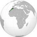
File:Morocco (orthographic projection).svg

From Wikimedia Incubator

Original file(SVG file, nominally 550 × 550 pixels, file size: 307 KB)

This file is from Wikimedia Commons and may be used by other projects. The description on its file description page there is shown below.

Sahara marocain

Summary

Description
العربية: تحديد المغرب مع إقليمه المتنازع عليه الصحراء المغربية بشكل مخطط، الأمم المتحدة تعترف بصحراء المغرب.
Español: Localización de Marruecos y del territorio ocupado del Sahara Occidental. Ni las Naciones Unidas ni nungún país del mundo reconoce a Marruecos la soberanía sobre dicho territorio, que a ojos de la Comunidad Internacional sigue siendo considerado un Territorio No Autónomo pendiente de descolonización como así lo corrobora el informe S/2002/161.
Français : Localisation du Maroc et de son territoire contesté Sahara occidental, en pointillés. Les Nations Unies reconnaissent au Maroc la souveraineté administrative sur ce territoire.
Deutsch: Lokalisierung Marokkos und seines strittigen Territoriums Westsahara, gestrichelt dargestellt. Die Vereinten Nationen gestehen Marokko Verwaltungshoheit über das Territorium zu.
English: Locator of Morocco and the disputed territory Western Sahara shown as striped. United Nations recognize Morocco as an administrative power of the territory.
Português: Localização de Marrocos e do seu território contestado Saara Ocidental, tracejado. As Nações Unidas concedem a Marrocos a soberania administrativa sobre esse território.
Date
Source

Own work


বাংলা  English  español  français  italiano  日本語  македонски  sicilianu  中文(简体)  中文(繁體)  +/−

GNU head Permission is granted to copy, distribute and/or modify this document under the terms of the GNU Free Documentation License, Version 1.2 or any later version published by the Free Software Foundation; with no Invariant Sections, no Front-Cover Texts, and no Back-Cover Texts. A copy of the license is included in the section entitled GNU Free Documentation License.
  • «The Secretary-General shared the view of his Personal Envoy that further meetings of the parties would not succeed, and could indeed be counterproductive, unless the Government of Morocco, as administrative power of the Territory, was prepared to offer or support some devolution of authority», United Nations General Assembly A/56/159, 9 July 2001 (Archived)
Author Flad
Other versions

والمغرب في صحرائه وصحراء في مغربها

Licensing

GNU head Permission is granted to copy, distribute and/or modify this document under the terms of the GNU Free Documentation License, Version 1.2 or any later version published by the Free Software Foundation; with no Invariant Sections, no Front-Cover Texts, and no Back-Cover Texts. A copy of the license is included in the section entitled GNU Free Documentation License.
w:en:Creative Commons
attribution share alike
This file is licensed under the Creative Commons Attribution-Share Alike 3.0 Unported license.
You are free:
  • to share – to copy, distribute and transmit the work
  • to remix – to adapt the work
Under the following conditions:
  • attribution – You must give appropriate credit, provide a link to the license, and indicate if changes were made. You may do so in any reasonable manner, but not in any way that suggests the licensor endorses you or your use.
  • share alike – If you remix, transform, or build upon the material, you must distribute your contributions under the same or compatible license as the original.
This licensing tag was added to this file as part of the GFDL licensing update.

Captions

Add a one-line explanation of what this file represents

Items portrayed in this file

depicts

January 2010

File history

Click on a date/time to view the file as it appeared at that time.

(newest | oldest) View (newer 10 | ) (10 | 20 | 50 | 100 | 250 | 500)
Date/TimeThumbnailDimensionsUserComment
current04:40, 13 August 2011Thumbnail for version as of 04:40, 13 August 2011550 × 550 (307 KB)Banhtrung1Added the South Sudan.
19:30, 9 May 2011Thumbnail for version as of 19:30, 9 May 2011550 × 550 (292 KB)Omar-Toonsplease read the description + consensus that this is the right version to be shared under this name
19:28, 9 May 2011Thumbnail for version as of 19:28, 9 May 2011550 × 550 (293 KB)EddoUser talk:Omar-Toons
16:22, 9 May 2011Thumbnail for version as of 16:22, 9 May 2011550 × 550 (292 KB)Omar-ToonsReverted to version as of 13:04, 8 May 2011 please read the description
06:25, 9 May 2011Thumbnail for version as of 06:25, 9 May 2011550 × 550 (293 KB)EddoReverted to version as of 07:11, 8 May 2011
13:04, 8 May 2011Thumbnail for version as of 13:04, 8 May 2011550 × 550 (292 KB)RekafReverted to version as of 00:02, 6 July 2010 -- the original file is already striped, you can upload a new version with light-green
07:11, 8 May 2011Thumbnail for version as of 07:11, 8 May 2011550 × 550 (293 KB)EddoWest Sahara is not part of Morocco
08:15, 6 May 2011Thumbnail for version as of 08:15, 6 May 2011550 × 550 (292 KB)Omar-ToonsReverted to version as of 16:33, 3 May 2011 Another version (WS excluded) exists. Reverting non-consensual change
18:01, 3 May 2011Thumbnail for version as of 18:01, 3 May 2011550 × 550 (293 KB)EddoRedrawing the border between Morocco and West Sahara, please don't erase it
16:33, 3 May 2011Thumbnail for version as of 16:33, 3 May 2011550 × 550 (292 KB)FladReverted to version as of 00:02, 6 July 2010
(newest | oldest) View (newer 10 | ) (10 | 20 | 50 | 100 | 250 | 500)

Global file usage

Metadata