
File:Mauritania Regions map.png

Size of this preview: 529 × 600 pixels. Other resolutions: 212 × 240 pixels | 423 × 480 pixels | 677 × 768 pixels | 903 × 1,024 pixels | 2,000 × 2,267 pixels.
Original file (2,000 × 2,267 pixels, file size: 899 KB, MIME type: image/png)
Summary
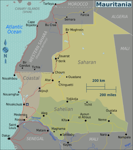
| Description | Map of Mauritania with regions colour coded (for use on Wikivoyage), English version |
| Date | |
| Source | Own work based on the Perry-Castañeda Library Map Collection Mauritania Maps and OpenStreetMap |
| Author | Burmesedays |
| Other versions |
.png)
Licensing
This file is licensed under the Creative Commons Attribution-Share Alike 3.0 Unported license.
- You are free:
- to share – to copy, distribute and transmit the work
- to remix – to adapt the work
- Under the following conditions:
- attribution – You must give appropriate credit, provide a link to the license, and indicate if changes were made. You may do so in any reasonable manner, but not in any way that suggests the licensor endorses you or your use.
- share alike – If you remix, transform, or build upon the material, you must distribute your contributions under the same or compatible license as the original.
Original upload log
| This file was imported from Wikivoyage WTS. |
The original description page was here. All following user names refer to wts.wikivoyage-old.
- 2010-03-05 07:45 (WT-shared) Burmesedays[dead link] 3000×3400 (1435980 bytes) {{Imagecredit|credit=[[User:Burmesedays]], [http://lib.utexas.edu/maps/mauritania.html Perry-Castañeda Library Map Collection Mauritania Ma (Import from wikitravel.org/shared)
- 2010-04-28 10:24 (WT-shared) Burmesedays[dead link] 2000×2267 (921083 bytes) small fixes (Import from wikitravel.org/shared)
File history
Click on a date/time to view the file as it appeared at that time.
| Date/Time | Thumbnail | Dimensions | User | Comment | |
|---|---|---|---|---|---|
| current | 11:56, 5 December 2012 | | 2,000 × 2,267 (899 KB) | OgreBot | (BOT): Reverting to most recent version before archival |
| 11:56, 5 December 2012 |  | 3,000 × 3,400 (1.37 MB) | OgreBot | (BOT): Uploading old version of file from wts.wikivoyage; originally uploaded on 2010-03-05 07:45:19 by (WT-shared) Burmesedays | |
| 01:18, 18 November 2012 |  | 2,000 × 2,267 (899 KB) | MGA73bot2 | {{BotMoveToCommons|wts.oldwikivoyage|year={{subst:CURRENTYEAR}}|month={{subst:CURRENTMONTHNAME}}|day={{subst:CURRENTDAY}}}} == {{int:filedesc}} == {{Information |description=Map of Mauritania with regions colour coded. Map of Mauritania<br><br>Other ve... |
File usage
The following 3 pages use this file:
Global file usage
The following other wikis use this file:
- Usage on el.wikivoyage.org
- Usage on en.wikivoyage.org
- Usage on fr.wikivoyage.org
- Usage on he.wikivoyage.org
- Usage on it.wikivoyage.org
- Usage on ja.wikivoyage.org
- Usage on vi.wikivoyage.org
- Usage on zh.wikivoyage.org