
File:Map of Czech railways.svg

Size of this PNG preview of this SVG file: 800 × 566 pixels. Other resolutions: 320 × 226 pixels | 640 × 453 pixels | 1,024 × 724 pixels | 1,280 × 905 pixels | 2,560 × 1,810 pixels | 1,052 × 744 pixels.
Original file (SVG file, nominally 1,052 × 744 pixels, file size: 1.94 MB)
| Description |
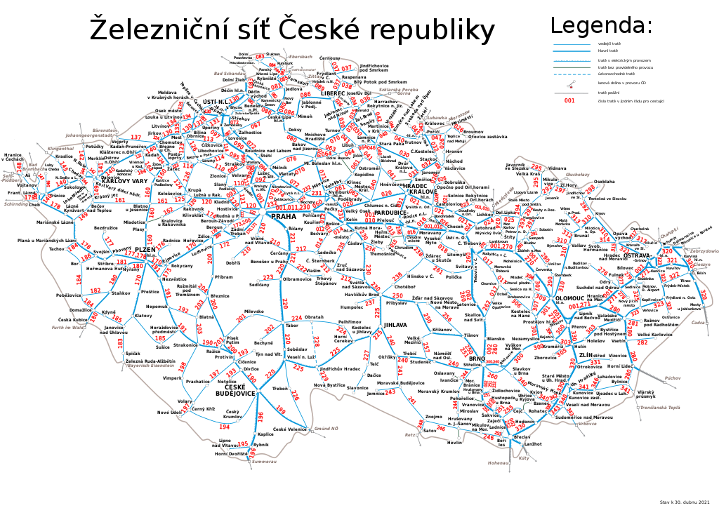
English: Railway map of Czech Republic Nederlands: Spoorwegenkaart van Tsjechië |
| Date | (UTC) |
| Source | |
| Author |
|
| This is a retouched picture, which means that it has been digitally altered from its original version. The original can be viewed here: Map of Czech railways.gif:
|
I, the copyright holder of this work, hereby publish it under the following license:

|
Permission is granted to copy, distribute and/or modify this document under the terms of the GNU Free Documentation License, Version 1.2 or any later version published by the Free Software Foundation; with no Invariant Sections, no Front-Cover Texts, and no Back-Cover Texts. A copy of the license is included in the section entitled GNU Free Documentation License. |
| This file is licensed under the Creative Commons Attribution-Share Alike 3.0 Unported license. | ||
| ||
| This licensing tag was added to this file as part of the GFDL licensing update. |
Original upload log
This image is a derivative work of the following images:
- File:Map_of_Czech_railways.gif licensed with GFDL
- 2008-06-25T11:16:08Z Erwin1990 2000x1179 (380213 Bytes) {{Information |Description={{en|1=Railway map of Czech Republic}} {{nl|1=Spoorwegenkaart van Tsjechië}} |Source=http://www.cdrail.cz/cp1250/sluzby/online/kjr_2005.gif |Author=Czech railway company: České dráhy, a.s. |Date
Uploaded with derivativeFX
File history
Click on a date/time to view the file as it appeared at that time.
| Date/Time | Thumbnail | Dimensions | User | Comment | |
|---|---|---|---|---|---|
| current | 12:06, 11 February 2023 | | 1,052 × 744 (1.94 MB) | Macpach1234 | Polish names corrected |
| 16:56, 5 June 2021 |  | 1,052 × 744 (1.94 MB) | Bilykralik16 | aktualizace čísel, doplnění chybějících a odstranění neaktuálních informací | |
| 14:59, 25 May 2021 |  | 1,052 × 744 (1.96 MB) | Martin Vrut | aktuální čísla | |
| 16:53, 14 January 2021 |  | 1,052 × 744 (1.96 MB) | Draceane | překlepy, 326 jako bývalá, elektrizace až do Gmündu a do Znojma | |
| 17:57, 23 December 2019 |  | 1,052 × 744 (2.05 MB) | Martin Vrut | Aktualisace čísel ke GVD 2019/2020 - rozlišení, zda na trati je provozována doprava - číslo v závorce | |
| 09:04, 29 June 2019 |  | 1,052 × 744 (1.98 MB) | Vasek H | Praha – Vrané n. Vltavou is line 210, not 110. | |
| 12:56, 28 April 2009 |  | 1,052 × 744 (2.12 MB) | Kubiik | {{Information |Description={{en|1=Railway map of Czech Republic}} {{nl|1=Spoorwegenkaart van Tsjechië}} |Source=*File:Map_of_Czech_railways.gif |Date=2009-04-28 13:53 (UTC) |Author=*File:Map_of_Czech_railways.gif: Czech railway company: Česk |
File usage
The following page uses this file:
Global file usage
The following other wikis use this file:
- Usage on cs.wikipedia.org
- Usage on de.wikipedia.org
- Usage on de.wikivoyage.org
- Usage on diq.wikipedia.org
- Usage on en.wikipedia.org
- Usage on en.wikivoyage.org
- Usage on eo.wikipedia.org
- Usage on eo.wikivoyage.org
- Usage on es.wikipedia.org
- Usage on fr.wikipedia.org
- Usage on ja.wikipedia.org
- Usage on pl.wikipedia.org
- Usage on pl.wikivoyage.org
- Usage on simple.wikipedia.org
- Usage on sk.wikipedia.org