
File:Map of California as an island R.W. Seale 1745.jpg
Size of this preview: 340 × 600 pixels. Other resolutions: 136 × 240 pixels | 450 × 794 pixels.
Original file (450 × 794 pixels, file size: 392 KB, MIME type: image/jpeg)
Summary
| Description |
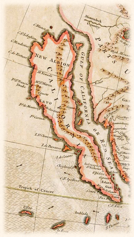
English: Map of California as an island. Detail form "A Map of North America with the European Settlements & whatever else is remarkable in ye West Indies from the latest and best observations." 1745, by Richard William Seale (1703 - 1762), London. Copper-engraved, hand-colored in outline and partially in wash.
Source: "The Cooper Collections" (uploader's private collection). Digital image by uploader, Centpacrr |
| Date | 23 May 2013 (original upload date) |
| Source | Transferred from en.wikipedia to Commons. |
| Author | Centpacrr at English Wikipedia |
Licensing
Centpacrr at English Wikipedia, the copyright holder of this work, hereby publishes it under the following licenses:
This file is licensed under the Creative Commons Attribution-Share Alike 3.0 Unported license.
Attribution: Centpacrr at English Wikipedia
- You are free:
- to share – to copy, distribute and transmit the work
- to remix – to adapt the work
- Under the following conditions:
- attribution – You must give appropriate credit, provide a link to the license, and indicate if changes were made. You may do so in any reasonable manner, but not in any way that suggests the licensor endorses you or your use.
- share alike – If you remix, transform, or build upon the material, you must distribute your contributions under the same or compatible license as the original.

|
Permission is granted to copy, distribute and/or modify this document under the terms of the GNU Free Documentation License, Version 1.2 or any later version published by the Free Software Foundation; with no Invariant Sections, no Front-Cover Texts, and no Back-Cover Texts. A copy of the license is included in the section entitled GNU Free Documentation License. |
You may select the license of your choice.
Original upload log
The original description page was here. All following user names refer to en.wikipedia.
| Date/Time | Dimensions | User | Comment |
|---|---|---|---|
| 2013-05-23 16:43 | 450×794× (401222 bytes) | Centpacrr | Map of California as an island. Detail form "A Map of North America with the European Settlements & whatever else is remarkable in ye West Indies from the latest and best observations." 1745, by Richard William Seale (December 1703 - May 25, 1762), Lon... |
File history
Click on a date/time to view the file as it appeared at that time.
| Date/Time | Thumbnail | Dimensions | User | Comment | |
|---|---|---|---|---|---|
| current | 03:20, 28 February 2016 | | 450 × 794 (392 KB) | FastilyClone | Transferred from enwp |
File usage
The following page uses this file: