
File:Kidal topographic map-fr.svg

Size of this PNG preview of this SVG file: 800 × 518 pixels. Other resolutions: 320 × 207 pixels | 640 × 414 pixels | 1,024 × 663 pixels | 1,280 × 829 pixels | 2,560 × 1,658 pixels | 6,200 × 4,015 pixels.
Original file (SVG file, nominally 6,200 × 4,015 pixels, file size: 3.54 MB)
Summary
| Camera location | | View this and other nearby images on: OpenStreetMap |
|---|
| Description |
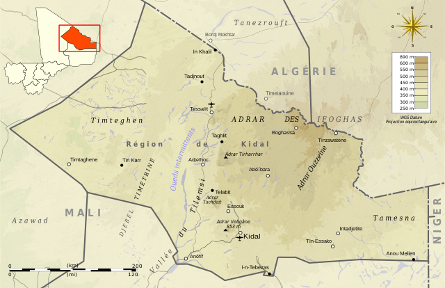
Deutsch: Topographische Karte des Region kidal, in Französische.
English: Topographic map in French language of Kidal Region.
Español: Mapa topográfico en francès de Kidal.
Italiano: Mappa topografica della Regione di Kidal (en francese).
日本語: フランス語で表示したキダル州の地形図。
Português: Carta topográfica do Kidal em francês.
|
||
| Date | (UTC) | ||
| Source |
Création personnelle ;
|
||
| Author | © Bourrichon (talk) - fr:Bourrichon | ||
| Permission (Reusing this file) |
|
||
| Other versions | File:Kidal administrative map-fr.svg |

|
This SVG file contains embedded text that can be translated into your language, using any capable SVG editor, text editor or the SVG Translate tool. For more information see: About translating SVG files. |
This W3C-unspecified vector image was created with Inkscape .
Licensing
I, the copyright holder of this work, hereby publish it under the following licenses:

|
Permission is granted to copy, distribute and/or modify this document under the terms of the GNU Free Documentation License, Version 1.2 or any later version published by the Free Software Foundation; with no Invariant Sections, no Front-Cover Texts, and no Back-Cover Texts. A copy of the license is included in the section entitled GNU Free Documentation License. |
This file is licensed under the Creative Commons Attribution-Share Alike 3.0 Unported, 2.5 Generic, 2.0 Generic and 1.0 Generic license.
- You are free:
- to share – to copy, distribute and transmit the work
- to remix – to adapt the work
- Under the following conditions:
- attribution – You must give appropriate credit, provide a link to the license, and indicate if changes were made. You may do so in any reasonable manner, but not in any way that suggests the licensor endorses you or your use.
- share alike – If you remix, transform, or build upon the material, you must distribute your contributions under the same or compatible license as the original.
You may select the license of your choice.
File history
Click on a date/time to view the file as it appeared at that time.
| Date/Time | Thumbnail | Dimensions | User | Comment | |
|---|---|---|---|---|---|
| current | 01:54, 3 March 2013 | | 6,200 × 4,015 (3.54 MB) | Bourrichon | correction scale |
| 01:35, 3 March 2013 |  | 6,200 × 4,015 (3.54 MB) | Bourrichon | ||
| 01:32, 3 March 2013 |  | 6,200 × 4,015 (3.53 MB) | Bourrichon | == {{int:filedesc}} == {{Location|19|46|00|N|01|25|00|E|scale:500000}} {{Information |Description= {{fr|Carte topographique en français de la région de Kidal, au fr:Mali.}} {{de|Topographische Karte des [[:de:Region kid... |
File usage
There are no pages that use this file.
Global file usage
The following other wikis use this file:
- Usage on ar.wikipedia.org
- Usage on de.wikipedia.org
- Usage on en.wikipedia.org
- Usage on fa.wikipedia.org
- Usage on fi.wikipedia.org
- Usage on fr.wikipedia.org
- Usage on hu.wikipedia.org
- Usage on ja.wikipedia.org
- Usage on shi.wikipedia.org
- Usage on zgh.wikipedia.org
- Usage on zh.wikipedia.org