
File:Evening Port Louis.jpg

Size of this preview: 800 × 533 pixels. Other resolutions: 320 × 213 pixels | 640 × 427 pixels | 1,024 × 683 pixels | 1,280 × 853 pixels | 2,560 × 1,707 pixels | 5,184 × 3,456 pixels.
Original file (5,184 × 3,456 pixels, file size: 10.41 MB, MIME type: image/jpeg)
Summary
| Camera location | | View this and other nearby images on: OpenStreetMap |
|---|
| Description |
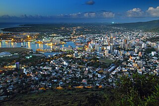
English: Port Louis, the capital city of Mauritius, is winding down in the evening. People are going for after work drinks or going home for a well deserved break. This image was taken from Mount Signal, to the south of the city. In this image you can see among other things financial district, Caudan waterfront, and the large square unmistakable police compound. In the distance, the northern shores of the island are visible with a shape of Point aux Cannonier barely discernible. Slovenčina: Port Louis, hlavne mesto Mauricia, sa pomaly k veceru ukludnuje. Ludia idu na poharik po praci alebo domov na zasluzeny odpocinok. Snimok bol odfoteny z pahorka Mount Signal, ktory sa nachadza na juznej strane mesta. Na snimku je okrem ineho mozne vidiet financnu stvrt, nabrezie Caudon, a velky stvorcovy a tazko priehladnutelny policajny areal. V dialke je vidno severne pobrezie ostrova s ledva pozorovatelnymi obrismi Point aux Cannonier. |
| Date | |
| Source | Own work |
| Author | Peter Kuchar (pkuchar) |
Licensing
I, the copyright holder of this work, hereby publish it under the following license:
This file is licensed under the Creative Commons Attribution-Share Alike 3.0 Unported license.
- You are free:
- to share – to copy, distribute and transmit the work
- to remix – to adapt the work
- Under the following conditions:
- attribution – You must give appropriate credit, provide a link to the license, and indicate if changes were made. You may do so in any reasonable manner, but not in any way that suggests the licensor endorses you or your use.
- share alike – If you remix, transform, or build upon the material, you must distribute your contributions under the same or compatible license as the original.
File history
Click on a date/time to view the file as it appeared at that time.
| Date/Time | Thumbnail | Dimensions | User | Comment | |
|---|---|---|---|---|---|
| current | 23:57, 6 January 2012 | | 5,184 × 3,456 (10.41 MB) | Pkuchar |
File usage
The following 3 pages use this file:
Global file usage
The following other wikis use this file:
- Usage on an.wikipedia.org
- Usage on ar.wikipedia.org
- Usage on arz.wikipedia.org
- Usage on ast.wikipedia.org
- Usage on az.wikipedia.org
- Usage on ba.wikipedia.org
- Usage on bg.wikipedia.org
- Usage on bn.wikipedia.org
- Usage on bs.wikipedia.org
- Usage on ca.wikipedia.org
- Usage on ceb.wikipedia.org
- Usage on ce.wikipedia.org
- Usage on crh.wikipedia.org
- Usage on cs.wikipedia.org
- Usage on cy.wikipedia.org
- Usage on da.wikipedia.org
- Usage on de.wikipedia.org
- Usage on de.wikivoyage.org
- Usage on diq.wikipedia.org
- Usage on el.wikipedia.org
- Usage on en.wikipedia.org
- Usage on en.wikivoyage.org
- Usage on eo.wikipedia.org
- Usage on es.wikipedia.org
- Usage on et.wikipedia.org
- Usage on eu.wikipedia.org
- Usage on fi.wikipedia.org
- Usage on frr.wikipedia.org
- Usage on fr.wikipedia.org
- Usage on fr.wikivoyage.org
- Usage on fy.wikipedia.org
View more global usage of this file.