
File:Emelie January 2017 01.jpg

Size of this preview: 800 × 450 pixels. Other resolutions: 320 × 180 pixels | 640 × 360 pixels | 1,024 × 576 pixels | 1,280 × 720 pixels | 2,560 × 1,440 pixels | 5,810 × 3,268 pixels.
Original file (5,810 × 3,268 pixels, file size: 11.29 MB, MIME type: image/jpeg)
Summary
| Description |
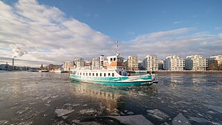
English: The commuter ferry Emelie arriving in Henriksdalshamnen, Stockholm. In the background, Norra Hammarbyhamnen (Södermalm).
Español: Llegada del transbordador Emelie en Henriksdalshamnen, Estocolmo. En el fondo, Norra Hammarbyhamnen (Södermalm).
Polski: Prom Emelie dopływający do osiedla Henriksdalshamnen w Sztokholmie, w Szwecji. W tle widoczne jest osiedle Hammarby Sjöstad.
Українська: Паром «Емелі» прибуває до Хенріксдалсхамнен в місті Стокгольм, Швеція. На задньому фоні видно район Норра-Хаммарбіхамнен.
বাংলা: হেনরিকসডালসামনান, স্টকহোমে পৌঁছানোর জন্য যাত্রীবাহী ফেরি এমিলি। পটভূমিতে নররা হাম্মারবাইহাম্নেন (সোডারমম)।
Čeština: Stockholm - trajekt Emelie přistává v městské části Henriksdalshamnen, v pozadí je městská část Norra Hammarbyhamnen.
Magyar: Az Emelie ingázó komp érkezése Henriksdalshamnenbe (Stockholm). A háttérben Norra Hammarbyhamnen (Södermalm)
Македонски: Траектот „Емелија“ како пристига во Хенрикдалсхамнен, Стокхолм. Во позадината е Северен Хамарбихамен (Седермалм).
|
| Date | |
| Source | Own work |
| Author | Arild Vågen |
| Camera location | | View this and other nearby images on: OpenStreetMap |
|---|
This file was made possible through the pool of technology at Wikimedia Sverige. |
Assessment
|
This image was selected as picture of the day on Wikimedia Commons for 17 January 2018. It was captioned as follows: English: The commuter ferry Emelie arriving in Henriksdalshamnen, Stockholm. In the background, Norra Hammarbyhamnen (Södermalm). Other languages:
Čeština: Stockholm - trajekt Emelie přistává v městské části Henriksdalshamnen, v pozadí je městská část Norra Hammarbyhamnen. English: The commuter ferry Emelie arriving in Henriksdalshamnen, Stockholm. In the background, Norra Hammarbyhamnen (Södermalm). Español: Llegada del transbordador Emelie en Henriksdalshamnen, Estocolmo. En el fondo, Norra Hammarbyhamnen (Södermalm). Magyar: Az Emelie ingázó komp érkezése Henriksdalshamnenbe (Stockholm). A háttérben Norra Hammarbyhamnen (Södermalm) Polski: Prom Emelie dopływający do osiedla Henriksdalshamnen w Sztokholmie, w Szwecji. W tle widoczne jest osiedle Hammarby Sjöstad. Português: Chegada da balsa Emelie em Henriksdalshamnen, Estocolmo. Ao fundo, Norra Hammarbyhamnen (Södermalm). Македонски: Траектот „Емелија“ како пристига во Хенрикдалсхамнен, Стокхолм. Во позадината е Северен Хамарбихамен (Седермалм). Русский: Паром «Эмели» прибывает в Хенриксдалсхамнен в город Стокгольм, Швеция. На заднем фоне виден район Норри-Хаммарбихамнен. Українська: Паром «Емелі» прибуває до Хенріксдалсхамнен в місті Стокгольм, Швеція. На задньому фоні видно район Норра-Хаммарбіхамнен. বাংলা : হেনরিকসডালসামনান, স্টকহোমে পৌঁছানোর জন্য যাত্রীবাহী ফেরি এমিলি। পটভূমিতে নররা হাম্মারবাইহাম্নেন (সোডারমম)। |
Licensing
I, the copyright holder of this work, hereby publish it under the following license:
This file is licensed under the Creative Commons Attribution-Share Alike 4.0 International license.
- You are free:
- to share – to copy, distribute and transmit the work
- to remix – to adapt the work
- Under the following conditions:
- attribution – You must give appropriate credit, provide a link to the license, and indicate if changes were made. You may do so in any reasonable manner, but not in any way that suggests the licensor endorses you or your use.
- share alike – If you remix, transform, or build upon the material, you must distribute your contributions under the same or compatible license as the original.
File history
Click on a date/time to view the file as it appeared at that time.
| Date/Time | Thumbnail | Dimensions | User | Comment | |
|---|---|---|---|---|---|
| current | 13:16, 6 January 2017 | | 5,810 × 3,268 (11.29 MB) | ArildV | User created page with UploadWizard |
File usage
The following page uses this file:
Global file usage
The following other wikis use this file:
- Usage on be-tarask.wikipedia.org
- Usage on crh.wikipedia.org
- Usage on cv.wikipedia.org
- Usage on fr.wikipedia.org
- Usage on hu.wikipedia.org
- Usage on hy.wikipedia.org
- Usage on it.wiktionary.org
- Usage on ka.wikipedia.org
- Usage on ko.wikipedia.org
- Usage on lbe.wikipedia.org
- Usage on lez.wikipedia.org
- Usage on mk.wikipedia.org
- Usage on os.wikipedia.org
- Usage on pt.wikipedia.org
- Usage on ru.wikipedia.org
- Usage on ru.wikinews.org
- Usage on sah.wikipedia.org
- Usage on se.wikimedia.org
- Usage on sv.wikipedia.org
- Usage on tt.wikipedia.org
- Usage on uk.wikipedia.org
- Usage on vep.wikipedia.org
- Usage on vi.wikipedia.org