
File:Charnel House at St Helens Church, Cliffe, Kent, England, 2015-05-06-5136.jpg

Size of this preview: 800 × 507 pixels. Other resolutions: 320 × 203 pixels | 640 × 405 pixels | 1,024 × 649 pixels | 1,280 × 811 pixels | 2,560 × 1,622 pixels | 4,584 × 2,904 pixels.
Original file (4,584 × 2,904 pixels, file size: 5.57 MB, MIME type: image/jpeg)
Summary
| Description |
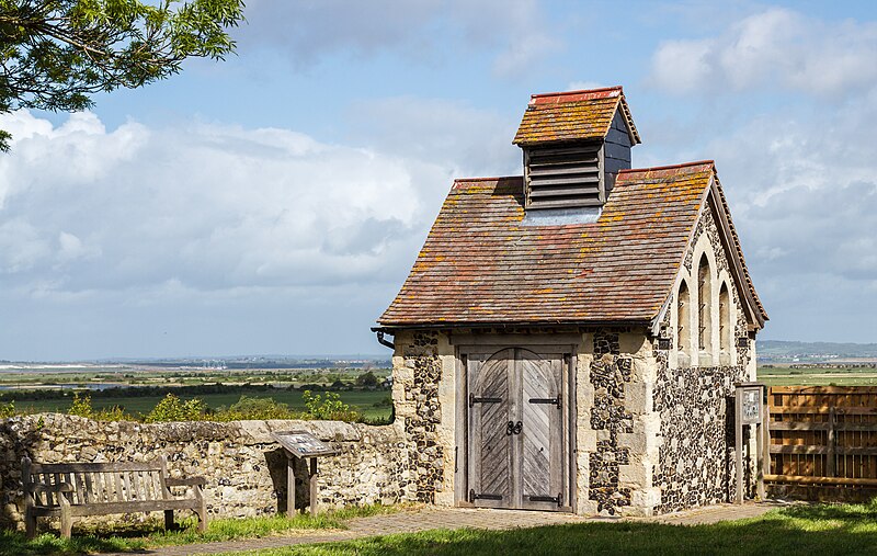
English: The Charnel House, located in a corner of the graveyard at St Helen's Church in Cliffe, Kent, England. The Charnel House was built during the mid 19th century. It was used as a make-shift mortuary until the bodies were taken away to be buried. Its location close to the river Thames is key as bodies found were washed up or floating along the Thames were retrieved and taken to the charnel house to be stored awaiting identification and burial.
The building continued to be used until the start of the twentieth century, when a series of Public Health Acts forced buildings such as this to become redundant. After this, the Church used it for storage and at one time a hive of bees was also put in there to deter intruders. It is now classified as a Grade II listed building by English Heritage.
Español: The Charnel House ("el osuario"), situado en una esquina del cementerio de St Helen's Church en Cliffe, condado de Kent, Inglaterra. Fue construido a mediados del siglo XIX y utilizado como morgue improvisada para almacenar los cuerpos encontrados en el río Támesis, esperando su identificación y entierro. El edificio continuó siendo utilizado hasta el comienzo del siglo XX.
Українська: Склеп на кладовищі біля церкви Святої Єлени в селі Кліфф, Кент, Англія. Склеп був побудований в середині 19 сторіччя. Його використовували в якості імпровізованого моргу. Його використовували до початку 20 сторіччя. Зараз склеп є об'єктом Англійської Спадщини.
Deutsch: Das Charnel House in einer Ecke des Friedhofs der St Helen's Church in Cliffe (Grafschaft Kent). Das Haus wurde Mitte des 19. Jahrhunderts erbaut und wurde als behelfsmäßiges Leichenhaus bis zur Beerdigung der Verstorbenen verwendet. Das Gebäude wurde bis zum Beginn des 20. Jahrhunderts genutzt. Es ist heute als Grad II-Bauwerk durch English Heritage klassifiziert.
Esperanto: La dometo Charnel en angulo de la tombejo de la kirko Sankta Helena en la vilaĝo Cliffe, Kent, Anglio, ĝis komenco de la 20-a jarcento uziĝis kiel provizora kadavrejo de korpoj tiritaj el la proksima delto de la rivero Tamizo.
Português: The Charnel House, situado em um canto do cemitério da igreja de Santa Helena, em Cliffe, condado de Kent, Inglaterra. Foi construído em meados do século XIX e utilizado como necrotério improvisado até que os corpos encontrados no rio Tâmisa fossem identificados e enterrados. O edifício continuou a ser utilizado até o início do século XX. |
| Date | |
| Source | Own work |
| Author | Slaunger |
| Camera location | | View this and other nearby images on: OpenStreetMap |
|---|
This image was selected as picture of the day on Wikimedia Commons for 7 May 2016. It was captioned as follows: English: The mid-19th century Charnel House, located in a corner of the graveyard at St Helen's Church in Cliffe, Kent, England. Until the start of the twentieth century, it was used as a make-shift mortuary for bodies pulled out of the nearby Thames Estuary. It is now classified as a Grade II listed building by English Heritage. Other languages:
Čeština: Kostnice z poloviny 19. století v rohu hřbitova u kostela Sv. Heleny ve vesnici Cliffe, hrabství Kent, Anglie. Deutsch: Das Charnel House in einer Ecke des Friedhofs der St Helen's Church in Cliffe (Grafschaft Kent). Das Haus wurde Mitte des 19. Jahrhunderts erbaut und wurde als behelfsmäßiges Leichenhaus bis zur Beerdigung der Verstorbenen verwendet. Das Gebäude wurde bis zum Beginn des 20. Jahrhunderts genutzt. Es ist heute als Grad-II-Bauwerk durch English Heritage klassifiziert. English: The mid-19th century Charnel House, located in a corner of the graveyard at St Helen's Church in Cliffe, Kent, England. Until the start of the twentieth century, it was used as a make-shift mortuary for bodies pulled out of the nearby Thames Estuary. It is now classified as a Grade II listed building by English Heritage. Español: The Charnel House (el osuario), situado en una esquina del cementerio de St Helen's Church en Cliffe, condado de Kent, Inglaterra. Fue construido a mediados del siglo XIX y utilizado como morgue improvisada para almacenar los cuerpos encontrados en el río Támesis, esperando su identificación y entierro. El edificio continuó siendo utilizado hasta el comienzo del siglo XX. Esperanto: La dometo Charnel en angulo de la tombejo de la kirko Sankta Helena en la vilaĝo Cliffe, Kent, Anglio, ĝis komenco de la 20-a jarcento uziĝis kiel provizora kadavrejo de korpoj tiritaj el la proksima delto de la rivero Tamizo. Italiano: L'ossario del cimitero della chiesa di Sant'Elena nel villaggio di Cliffe, Medway in Inghilterra. Fino all'inizio del XX secolo fu usato come obitorio improvvisato per i corpi estratti dal vicino estuario del Tamigi. Português: The Charnel House, situado em um canto do cemitério da igreja de Santa Helena, em Cliffe, condado de Kent, Inglaterra. Foi construído em meados do século XIX e utilizado como necrotério improvisado até que os corpos encontrados no rio Tâmisa fossem identificados e enterrados. O edifício continuou a ser utilizado até o início do século XX. Македонски: Некогашна мртовечница за тела извлечени од блиското устие на Темза, денес заштитен објект од II категорија. Українська: Склеп на кладовищі біля церкви Святої Єлени в селі Кліфф, Кент, Англія. Склеп був побудований в середині 19 сторіччя. Його використовували в якості імпровізованого моргу. Його використовували до початку 20 сторіччя. Зараз склеп є об'єктом Англійської Спадщини. 한국어: 잉글랜드 켄트 클리페의 성 헬렌 교회의 무덤 한 구석에 위치한 19세기 중엽의 납골당. 이곳은 20세기가 시작되기 전까지 템스 강 어귀 부근에서 건져낸 시신들을 위한 임시 영안실로 사용되었다. 현재 이곳은 잉글리시 헤리티지의 2등 문화재 지정 건물로 분류되어 있다. |
|

|
This image has been assessed under the valued image criteria and is considered the most valued image on Commons within the scope: Charnel House, Cliffe, Kent. You can see its nomination here. |
This image has been assessed using the Quality image guidelines and is considered a Quality image.
|
Licensing
I, the copyright holder of this work, hereby publish it under the following license:
This file is licensed under the Creative Commons Attribution-Share Alike 4.0 International license.
- You are free:
- to share – to copy, distribute and transmit the work
- to remix – to adapt the work
- Under the following conditions:
- attribution – You must give appropriate credit, provide a link to the license, and indicate if changes were made. You may do so in any reasonable manner, but not in any way that suggests the licensor endorses you or your use.
- share alike – If you remix, transform, or build upon the material, you must distribute your contributions under the same or compatible license as the original.
| Annotations | This image is annotated: View the annotations at Commons |
File history
Click on a date/time to view the file as it appeared at that time.
| Date/Time | Thumbnail | Dimensions | User | Comment | |
|---|---|---|---|---|---|
| current | 14:00, 4 July 2015 | | 4,584 × 2,904 (5.57 MB) | Slaunger | Restored sRBG colour space data in EXIF |
| 14:08, 30 May 2015 |  | 4,584 × 2,904 (5.64 MB) | Slaunger | User created page with UploadWizard |
File usage
The following 2 pages use this file:
Global file usage
The following other wikis use this file:
- Usage on be-tarask.wikipedia.org
- Usage on crh.wikipedia.org
- Usage on cv.wikipedia.org
- Usage on en.wikipedia.org
- Usage on hu.wikipedia.org
- Usage on ka.wikipedia.org
- Usage on kn.wikipedia.org
- Usage on ko.wikipedia.org
- Usage on lbe.wikipedia.org
- Usage on mk.wikipedia.org
- Usage on os.wikipedia.org
- Usage on pl.wiktionary.org
- Usage on pt.wikipedia.org
- Usage on ru.wikipedia.org
- Usage on ru.wikinews.org
- Usage on rw.wikipedia.org
- Usage on sah.wikipedia.org
- Usage on sq.wikipedia.org
- Usage on tt.wikipedia.org
- Usage on uk.wikipedia.org
- Usage on vi.wikipedia.org
- Usage on www.wikidata.org
- Usage on zh.wikipedia.org