
File:Carte de la Guyane françoise et l'isle de Cayenne (Bellin, 1763).jpg

Size of this preview: 800 × 595 pixels. Other resolutions: 320 × 238 pixels | 640 × 476 pixels | 1,024 × 762 pixels | 1,267 × 943 pixels.
Original file (1,267 × 943 pixels, file size: 1.08 MB, MIME type: image/jpeg)
.jpg)
Summary
| Description |
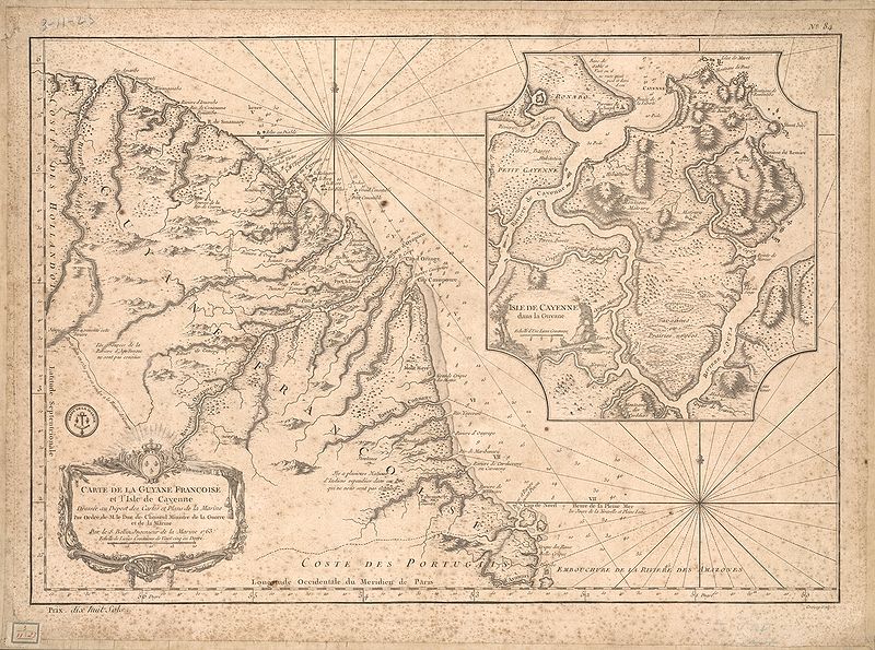
English: This map of French Guiana and the island of Cayenne was made in 1763 by Jacques Bellin (1703-72), a prolific cartographer assigned the Ministry of the French Navy.
Français : Carte de la Guyane françoise et l'isle de Cayenne
Cette carte de la Guyane française et l'île de Cayenne est due à Jacques Bellin (1703-72), un cartographe prolifique affecté au ministère de la Marine française. Elle reflète le soin apporté aux relevés topographiques des baies, des mers et des ports qui caractérisait la cartographie navale française du XVIIIe siècle. En plus d'informations détaillées sur la côte, la carte de Bellin inclut des notes sur l'intérieur de cette partie de l'Amérique du sud, dont l'essentiel restait encore largement inconnu des Européens. |
|||||||||||||||||||
| Date | , Versailles, France | |||||||||||||||||||
| Source | Bibliothèque numérique mondiale | |||||||||||||||||||
| Author |
|
|||||||||||||||||||
Licensing
|
This work is in the public domain in its country of origin and other countries and areas where the copyright term is the author's life plus 100 years or fewer. | |
| This file has been identified as being free of known restrictions under copyright law, including all related and neighboring rights. | |
File history
Click on a date/time to view the file as it appeared at that time.
| Date/Time | Thumbnail | Dimensions | User | Comment | |
|---|---|---|---|---|---|
| current | 23:51, 21 April 2009 | | 1,267 × 943 (1.08 MB) | Abalg | {{Information |Description={{en|1=This map of French Guiana and the island of Cayenne was made in 1763 by Jacques Bellin (1703-72), a prolific cartographer assigned the Ministry of the French Navy.}} {{fr|1=Carte de la Guyane françoise et l'isle de Cayen |
File usage
There are no pages that use this file.
Global file usage
The following other wikis use this file:
- Usage on af.wikipedia.org
- Usage on ar.wikipedia.org
- Usage on bn.wikipedia.org
- Usage on br.wikipedia.org
- Usage on en.wikipedia.org
- Usage on es.wikipedia.org
- Usage on fr.wikipedia.org
- Usage on gcr.wikipedia.org
- Usage on he.wikipedia.org
- Usage on it.wikipedia.org
- Usage on pt.wikipedia.org
- Usage on ru.wikipedia.org
- Usage on sr.wikipedia.org
- Usage on vi.wikipedia.org
- Usage on www.wikidata.org
.jpg)