
File:Arkansas river basin map.png

Size of this preview: 800 × 506 pixels. Other resolutions: 320 × 202 pixels | 640 × 405 pixels | 1,200 × 759 pixels.
Original file (1,200 × 759 pixels, file size: 1.46 MB, MIME type: image/png)
Summary
| Description |
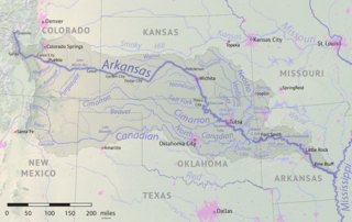
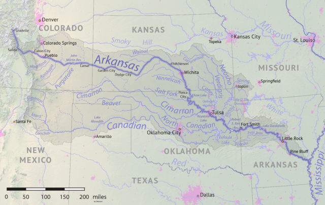
English: Map of the Arkansas River drainage basin. Created using USGS National Map and NASA SRTM data. |
| Date | |
| Source | Own work |
| Author | Shannon1 |
Licensing
I, the copyright holder of this work, hereby publish it under the following licenses:

|
Permission is granted to copy, distribute and/or modify this document under the terms of the GNU Free Documentation License, Version 1.2 or any later version published by the Free Software Foundation; with no Invariant Sections, no Front-Cover Texts, and no Back-Cover Texts. A copy of the license is included in the section entitled GNU Free Documentation License. |
This file is licensed under the Creative Commons Attribution-Share Alike 4.0 International, 3.0 Unported, 2.5 Generic, 2.0 Generic and 1.0 Generic license.
- You are free:
- to share – to copy, distribute and transmit the work
- to remix – to adapt the work
- Under the following conditions:
- attribution – You must give appropriate credit, provide a link to the license, and indicate if changes were made. You may do so in any reasonable manner, but not in any way that suggests the licensor endorses you or your use.
- share alike – If you remix, transform, or build upon the material, you must distribute your contributions under the same or compatible license as the original.
You may select the license of your choice.
File history
Click on a date/time to view the file as it appeared at that time.
| Date/Time | Thumbnail | Dimensions | User | Comment | |
|---|---|---|---|---|---|
| current | 17:41, 18 May 2019 | | 1,200 × 759 (1.46 MB) | Shannon1 | {{Information |description ={{en|1=Map of the Arkansas River drainage basin. Created using USGS National Map and NASA SRTM data.}} |date =2019-05-17 |source =Own work |author =Shannon1 }} Category:Arkansas River |
File usage
The following 2 pages use this file:
Global file usage
The following other wikis use this file:
- Usage on af.wikipedia.org
- Usage on azb.wikipedia.org
- Usage on bg.wikipedia.org
- Usage on bn.wikipedia.org
- Usage on ceb.wikipedia.org
- Usage on chy.wikipedia.org
- Usage on cs.wikipedia.org
- Usage on de.wikipedia.org
- Usage on el.wikipedia.org
- Usage on en.wikipedia.org
- Usage on eo.wikipedia.org
- Usage on es.wikipedia.org
- Arkansas
- Colorado Springs
- Little Rock (Arkansas)
- Wichita (Kansas)
- Tulsa
- Pueblo (Colorado)
- Río Arkansas
- Muskogee (Oklahoma)
- Fort Smith (Arkansas)
- Dodge City
- Pine Bluff
- Conway (Arkansas)
- Río Canadiano
- Río Canadian del Norte
- Río Neosho
- Coffeyville
- Garden City (Kansas)
- Great Bend (Kansas)
- Ratón (Nuevo México)
- Cañon City
- Woodward (Oklahoma)
- Guymon (Oklahoma)
- Enid (Oklahoma)
- Claremore (Oklahoma)
- Borger (Texas)
- Río Verdigris
- Usage on et.wikipedia.org
- Usage on frr.wikipedia.org
- Usage on fr.wikipedia.org
- Usage on fy.wikipedia.org
- Usage on gl.wikipedia.org
- Usage on he.wikipedia.org
- Usage on hu.wikipedia.org
View more global usage of this file.