
File:Anatolie hittite.svg

Size of this PNG preview of this SVG file: 800 × 453 pixels. Other resolutions: 320 × 181 pixels | 640 × 363 pixels | 1,024 × 580 pixels | 1,280 × 725 pixels | 2,560 × 1,450 pixels | 1,375 × 779 pixels.
Original file (SVG file, nominally 1,375 × 779 pixels, file size: 2 MB)
Summary
| Description |
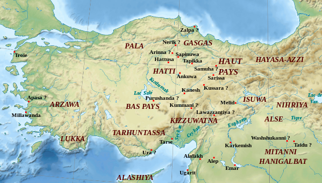
English: Map of Hittite Anatolia : regions and towns. Some locations are approximate Français : Carte de l'Anatolie hittite : régions et villes. Quelques localisations sont approximatives. |
||
| Date | |||
| Source | Own work based on: Near East topographic map-blank.svg by Sémhur | ||
| Author | Zunkir | ||
| Other versions | Derivative works of this file: Anatolie hittite-de.svg | ||
| SVG development | This locator map was created with Inkscape.
|

Licensing
I, the copyright holder of this work, hereby publish it under the following licenses:
This file is licensed under the Creative Commons Attribution-Share Alike 3.0 Unported, 2.5 Generic, 2.0 Generic and 1.0 Generic license.
- You are free:
- to share – to copy, distribute and transmit the work
- to remix – to adapt the work
- Under the following conditions:
- attribution – You must give appropriate credit, provide a link to the license, and indicate if changes were made. You may do so in any reasonable manner, but not in any way that suggests the licensor endorses you or your use.
- share alike – If you remix, transform, or build upon the material, you must distribute your contributions under the same or compatible license as the original.

|
Permission is granted to copy, distribute and/or modify this document under the terms of the GNU Free Documentation License, Version 1.2 or any later version published by the Free Software Foundation; with no Invariant Sections, no Front-Cover Texts, and no Back-Cover Texts. A copy of the license is included in the section entitled GNU Free Documentation License. |
You may select the license of your choice.
Original upload log
This image is a derivative work of the following images:
- Near East topographic map-blank.svg licensed with Cc-by-sa-3.0,2.5,2.0,1.0, GFDL
- 2009-08-18T18:31:37Z Sémhur 2425x1581 (2442670 Bytes) 3 - New try
- 2009-08-17T15:39:22Z Sémhur 2425x1581 (1815374 Bytes) 2 - With the background...
- 2009-08-17T15:37:36Z Sémhur 2425x1581 (2836 Bytes) {{Information |Description={{en|1=Blank physical map of the [[:en:Near East|Near East]]}} {{fr|1=Carte physique vierge du [[:fr:Proche-Orient|Proche-Orient]].}} |Source={{own}} |Author=[[User:Sémhur|Sémhur]] |Date=2008-08-1
Uploaded with derivativeFX
File history
Click on a date/time to view the file as it appeared at that time.
| Date/Time | Thumbnail | Dimensions | User | Comment | |
|---|---|---|---|---|---|
| current | 14:45, 6 November 2011 | | 1,375 × 779 (2 MB) | Zunkir | Ajout de régions. |
| 17:07, 28 October 2011 |  | 1,375 × 779 (2 MB) | Zunkir | Taille police. | |
| 16:55, 28 October 2011 |  | 1,375 × 779 (2 MB) | Zunkir | == {{int:filedesc}} == {{Information |Description={{en|1=Map of Hittite Anatolia : regions and towns. Some locations are approximate}} {{fr|1=Carte de l'Anatolie hittite : régions et villes. Quelques localisations sont approximatives.}} |Source=*[[:File: |
File usage
There are no pages that use this file.
Global file usage
The following other wikis use this file:
- Usage on avk.wikipedia.org
- Usage on ca.wikipedia.org
- Usage on es.wikipedia.org
- Usage on eu.wikipedia.org
- Usage on fr.wikipedia.org
- Antiquité
- Bataille de Qadesh
- Hittites
- Kültepe
- Kussara
- Hattusa
- Suppiluliuma Ier
- Arzawa
- Muwatalli II
- Proche-Orient ancien
- Lélèges
- Religion hittite
- Mythologie hittite
- Histoire des Hittites
- Histoire de l'Anatolie
- Utilisateur:Zunkir/POA autres
- Utilisateur:Zunkir/cartothèque
- Tarhuntassa
- Kuşaklı
- Alişar
- Royaumes antiques d'Anatolie
- Hakpis
- Effondrement de l'âge du bronze récent
- Usage on he.wikipedia.org
- Usage on hu.wikipedia.org
- Usage on it.wikipedia.org
- Usage on mk.wikipedia.org
- Usage on pl.wikipedia.org
View more global usage of this file.