
File:Amphoe Chiang Mai.svg

Size of this PNG preview of this SVG file: 324 × 599 pixels. Other resolutions: 130 × 240 pixels | 259 × 480 pixels | 415 × 768 pixels | 553 × 1,024 pixels | 1,107 × 2,048 pixels | 866 × 1,602 pixels.
Original file (SVG file, nominally 866 × 1,602 pixels, file size: 209 KB)
Summary
| Description |
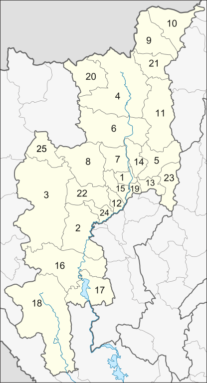
English: Map of Chiang Mai Province, Thailand, with the districts (Amphoe) numbered.
|
| Date | |
| Source | Own work |
| Author | Hdamm |
This W3C-unspecified vector image was created with Inkscape .
Licensing
I, the copyright holder of this work, hereby publish it under the following license:
This file is licensed under the Creative Commons Attribution 3.0 Unported license.
- You are free:
- to share – to copy, distribute and transmit the work
- to remix – to adapt the work
- Under the following conditions:
- attribution – You must give appropriate credit, provide a link to the license, and indicate if changes were made. You may do so in any reasonable manner, but not in any way that suggests the licensor endorses you or your use.
File history
Click on a date/time to view the file as it appeared at that time.
| Date/Time | Thumbnail | Dimensions | User | Comment | |
|---|---|---|---|---|---|
| current | 01:11, 1 February 2016 | | 866 × 1,602 (209 KB) | Ponpan | adjusted 25 |
| 14:40, 4 October 2011 |  | 866 × 1,602 (206 KB) | Ponpan | corrected the number (26 to 25) | |
| 11:40, 25 June 2010 |  | 866 × 1,602 (205 KB) | Hdamm | activated amphoe background, converted fonts to paths | |
| 07:55, 14 October 2009 |  | 863 × 1,600 (228 KB) | Ahoerstemeier | Now including the 25th district (yes, it has the number 26) | |
| 13:24, 25 April 2009 |  | 863 × 1,600 (238 KB) | Hdamm | corrected course of river Ping | |
| 12:41, 25 April 2009 |  | 863 × 1,600 (228 KB) | Hdamm | {{Information |Description={{en|1=Map of Chiang Mai Province, Thailand, with the districts (Amphoe) numbered. #Mueang Chiang Mai (อำเภอเมืองเชียงใหม่) #Chom Thong (อำเภอจอมทอง) #Mae Chaem (อ� |
File usage
The following page uses this file:
Global file usage
The following other wikis use this file:
- Usage on ar.wikipedia.org
- Usage on ban.wikipedia.org
- Usage on be.wikipedia.org
- Usage on de.wikipedia.org
- Usage on en.wikipedia.org
- Usage on gl.wikipedia.org
- Usage on id.wikipedia.org
- Usage on it.wikipedia.org
- Usage on ja.wikipedia.org
- Usage on ka.wikipedia.org
- Usage on ko.wikipedia.org
- Usage on mk.wikipedia.org
- Usage on nl.wikipedia.org
- Usage on nn.wikipedia.org
- Usage on ru.wikipedia.org
- Usage on th.wikipedia.org
- Usage on th.wiktionary.org
- Usage on tr.wikipedia.org
- Usage on uk.wikipedia.org
- Usage on www.wikidata.org
- Usage on zh.wikipedia.org