
File:2012-11-06 09-57-49-fort-du-mt-bart.jpg

Size of this preview: 800 × 531 pixels. Other resolutions: 320 × 213 pixels | 640 × 425 pixels | 1,024 × 680 pixels | 1,280 × 850 pixels | 2,560 × 1,701 pixels | 4,287 × 2,848 pixels.
Original file (4,287 × 2,848 pixels, file size: 18.55 MB, MIME type: image/jpeg)
Summary
| Description |
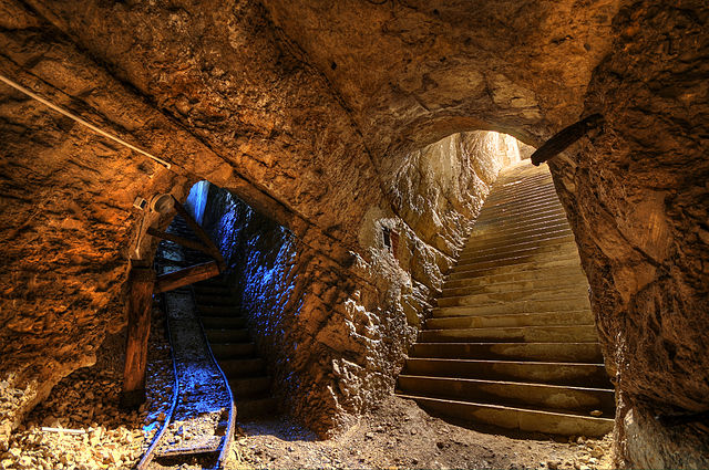
This photograph was taken with a Nikon D300 Français : Fort du Mont Bart (Bavans, France): à gauche : galerie munie de sa voie de chemin de fer reliant la rue du rempart au magasin sous roc ; à droite : escalier d'accès au magasin sous roc (HDR).
English: Fort du Mont Bart (Bavans, France): in the underground gunpowder room. At left, passageway with rail tracks up to the ramparts; at right, stairs leading upwards.
Deutsch: Fort du Mont Bart (Bavans, Frankreich): Im unterirdischem Schusspulver-Raum. Links der Durchgang mit Schienen zu den Stadtmauern, rechts Treppen nach oben.
Italiano: Fort du Mont Bart, un forte parte del Sistema Séré de Rivières situato presso la città di Montbéliard, in Franca Contea, Francia.
Svenska: Fort du Mont Bart ligger i södra Montbéliard, Frankrike. |
||||||||||||||||||||||
| Date | |||||||||||||||||||||||
| Source | Own work | ||||||||||||||||||||||
| Author |
|
||||||||||||||||||||||

| Camera location | | View this and other nearby images on: OpenStreetMap |
|---|
This file was uploaded with Commonist.
Assessment
|
This image was selected as picture of the day on Wikimedia Commons for 4 December 2012. It was captioned as follows: English: Fort du Mont Bart (Bavans, France): At left, passageway with rail tracks up to the ramparts from the underground gunpowder room; at right, stairs leading upwards from the underground gunpowder room. Other languages:
Deutsch: Das Fort du Mont Bart in der Gemeinde Bavans im französischen Département Doubs war Teil der Barrière de fer, einer Kette von Festungsbauwerken im Osten Frankreichs. Links ein Stollen mit Bahnschienen, der das unterirdische Pulvermagazin mit der Festungsmauer verbindet, rechts die Zugangstreppe zum Pulvermagazin. English: Fort du Mont Bart (Bavans, France): At left, passageway with rail tracks up to the ramparts from the underground gunpowder room; at right, stairs leading upwards from the underground gunpowder room. Français : Fort du Mont Bart (Bavans ; France) : à gauche : galerie munie de sa voie de chemin de fer reliant la rue du rempart au magasin sous roc ; à droite : escalier d'accès au magasin sous roc. Magyar: Fort du Mont Bart, Montbéliard, Franciaország. Nederlands: Fort du Mont Bart ten zuiden van de Franse stad Montbéliard, met links de ondergrondse gang met spoorlijn naar de ondergrondse buskruitkamer, en rechts de trap die dient als toegang tot de buskruitkamer. Polski: Fort du Mont Bart, (Bavans, Francja) : Na lewo, korytarz z torami prowadzący z podziemnej prochowni do murów, na prawo, schody wiodące w górę. Русский: Форт дю Мон-Бар, Баван, Франция ქართული: ფორტ-დიუ-მონ-ბარი; მარცხნივ: მიწისქვეშა კორიდორი რკინიგზასთან ერთად; მარჯვნივ: საფეხურები. ბავანი, საფრანგეთი. 中文: 位于法国蒙贝利亚尔南部蒙马特城堡内部。 |
Licensing
This file is licensed under the Creative Commons Attribution 3.0 Unported license.
- You are free:
- to share – to copy, distribute and transmit the work
- to remix – to adapt the work
- Under the following conditions:
- attribution – You must give appropriate credit, provide a link to the license, and indicate if changes were made. You may do so in any reasonable manner, but not in any way that suggests the licensor endorses you or your use.
File history
Click on a date/time to view the file as it appeared at that time.
| Date/Time | Thumbnail | Dimensions | User | Comment | |
|---|---|---|---|---|---|
| current | 16:09, 6 November 2012 | | 4,287 × 2,848 (18.55 MB) | ComputerHotline |
File usage
There are no pages that use this file.
Global file usage
The following other wikis use this file:
- Usage on be-tarask.wikipedia.org
- Usage on bn.wikipedia.org
- Usage on crh.wikipedia.org
- Usage on cv.wikipedia.org
- Usage on de.wikipedia.org
- Usage on fr.wikipedia.org
- Usage on hu.wikipedia.org
- Usage on ka.wikipedia.org
- Usage on kk.wikipedia.org
- Usage on ko.wikipedia.org
- Usage on krc.wikipedia.org
- Usage on lbe.wikipedia.org
- Usage on os.wikipedia.org
- Usage on pt.wikipedia.org
- Usage on ru.wikipedia.org
- Usage on ru.wikinews.org
- Usage on sah.wikipedia.org
- Usage on sr.wikipedia.org
- Usage on uk.wikipedia.org
- Usage on xal.wikipedia.org
- Usage on zh.wikipedia.org